You are here: Home > Network List > II - Global Seismograph Network (GSN - IRIS/IDA) Stations List
> Station KAPI Kappang, Sulawesi, Indonesia > Earthquake Result Viewer
KAPI Kappang, Sulawesi, Indonesia - Earthquake Result Viewer
| Earthquake location: |
Solomon Islands |
| Earthquake latitude/longitude: |
-9.0/157.6 |
| Earthquake time(UTC): |
2010/01/05 (005) 12:15:32 GMT |
| Earthquake Depth: |
15 km |
| Earthquake Magnitude: |
6.8 MW, 6.2 MB, 6.7 MS, 6.8 MW |
| Earthquake Catalog/Contributor: |
NEIC PDE/NEIC PDE-M |
|
| Network: |
II Global Seismograph Network (GSN - IRIS/IDA) |
| Station: |
KAPI Kappang, Sulawesi, Indonesia |
| Lat/Lon: |
5.01 S/119.75 E |
| Elevation: |
300 m |
|
| Distance: |
37.7 deg |
| Az: |
273.452 deg |
| Baz: |
98.213 deg |
| Ray Param: |
0.07596854 |
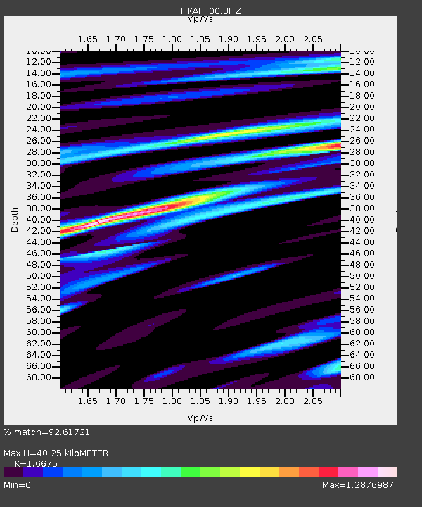
| Estimated Moho Depth: |
40.25 km |
| Estimated Crust Vp/Vs: |
1.67 |
| Assumed Crust Vp: |
6.343 km/s |
| Estimated Crust Vs: |
3.804 km/s |
| Estimated Crust Poisson's Ratio: |
0.22 |
|
| Radial Match: |
92.61721 % |
| Radial Bump: |
400 |
| Transverse Match: |
75.0482 % |
| Transverse Bump: |
400 |
| SOD ConfigId: |
617450 |
| Insert Time: |
2013-09-30 21:28:57.512 +0000 |
| GWidth: |
2.5 |
| Max Bumps: |
400 |
| Tol: |
0.001 |
|

Signal To Noise
| Channel | StoN | STA | LTA |
| II:KAPI:00:BHZ:20100105T12:22:16.219003Z | 5.8780684 | 9.578625E-7 | 1.629553E-7 |
| II:KAPI:00:BH1:20100105T12:22:16.219003Z | 1.1307695 | 1.4614315E-7 | 1.2924221E-7 |
| II:KAPI:00:BH2:20100105T12:22:16.219003Z | 4.0982504 | 5.779345E-7 | 1.4101981E-7 |
| Arrivals |
| Ps | 4.6 SECOND |
| PpPs | 16 SECOND |
| PsPs/PpSs | 20 SECOND |


