You are here: Home > Network List > GS - US Geological Survey Networks Stations List
> Station KAN13 Rinehart Farm > Earthquake Result Viewer
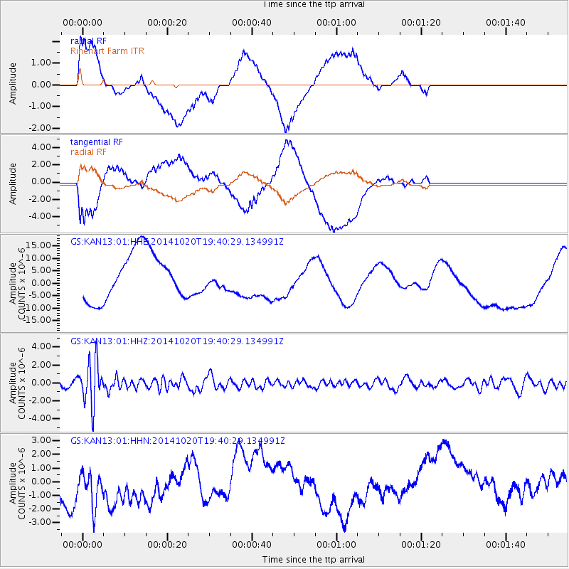
KAN13 Rinehart Farm - Earthquake Result Viewer
*The percent match for this event was below the threshold and hence no stack was calculated.
| Earthquake location: |
Colombia-Ecuador Border Region |
| Earthquake latitude/longitude: |
0.6/-77.8 |
| Earthquake time(UTC): |
2014/10/20 (293) 19:33:21 GMT |
| Earthquake Depth: |
10 km |
| Earthquake Magnitude: |
6.0 MB, 5.6 MWB |
| Earthquake Catalog/Contributor: |
NEIC PDE/NEIC COMCAT |
|
| Network: |
GS US Geological Survey Networks |
| Station: |
KAN13 Rinehart Farm |
| Lat/Lon: |
37.01 N/97.48 W |
| Elevation: |
340 m |
|
| Distance: |
40.5 deg |
| Az: |
335.558 deg |
| Baz: |
148.876 deg |
| Ray Param: |
$rayparam |
*The percent match for this event was below the threshold and hence was not used in the summary stack. |
|
| Radial Match: |
40.254524 % |
| Radial Bump: |
400 |
| Transverse Match: |
41.6536 % |
| Transverse Bump: |
400 |
| SOD ConfigId: |
3390531 |
| Insert Time: |
2019-04-14 15:40:30.442 +0000 |
| GWidth: |
2.5 |
| Max Bumps: |
400 |
| Tol: |
0.001 |
|
Signal To Noise
| Channel | StoN | STA | LTA |
| GS:KAN13:01:HHZ:20141020T19:40:29.134991Z | 9.081737 | 2.3501252E-6 | 2.5877486E-7 |
| GS:KAN13:01:HHN:20141020T19:40:29.134991Z | 1.0018175 | 1.8756105E-6 | 1.8722077E-6 |
| GS:KAN13:01:HHE:20141020T19:40:29.134991Z | 0.46281877 | 4.359121E-6 | 9.418634E-6 |
| Arrivals |
| Ps | |
| PpPs | |
| PsPs/PpSs | |


