You are here: Home > Network List > IU - Global Seismograph Network (GSN - IRIS/USGS) Stations List
> Station RSSD Black Hills, South Dakota, USA > Earthquake Result Viewer
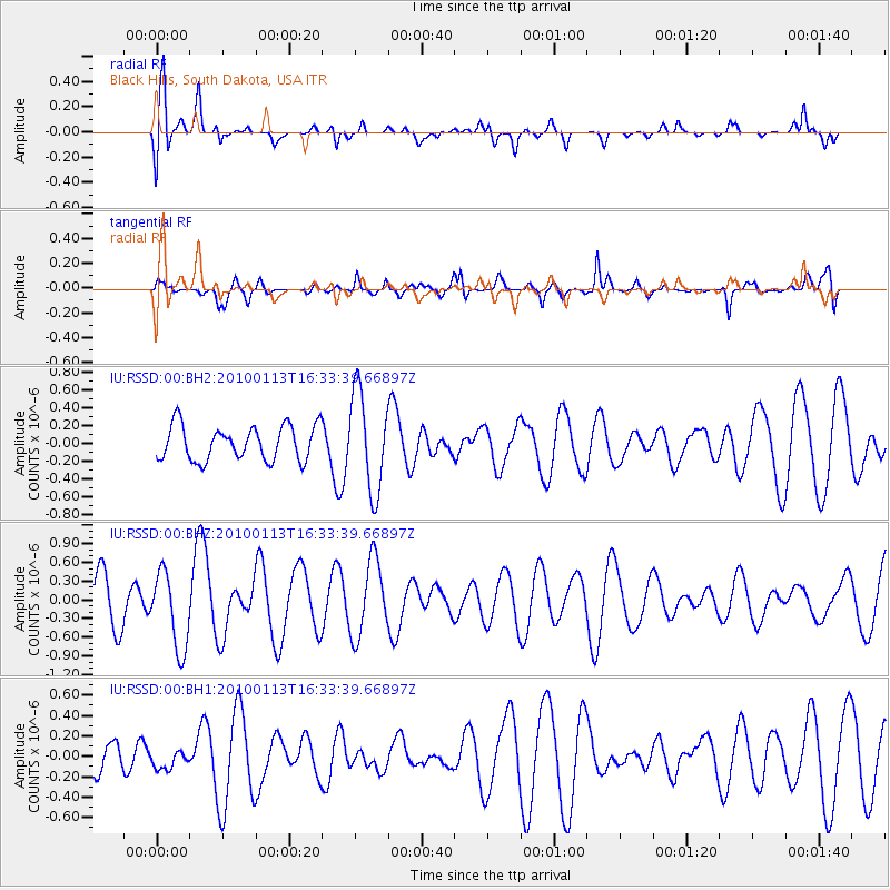
RSSD Black Hills, South Dakota, USA - Earthquake Result Viewer
*The percent match for this event was below the threshold and hence no stack was calculated.
| Earthquake location: |
Tonga Islands |
| Earthquake latitude/longitude: |
-15.7/-174.8 |
| Earthquake time(UTC): |
2010/01/13 (013) 16:21:23 GMT |
| Earthquake Depth: |
10 km |
| Earthquake Magnitude: |
5.5 MW |
| Earthquake Catalog/Contributor: |
NEIC PDE/NEIC PDE-M |
|
| Network: |
IU Global Seismograph Network (GSN - IRIS/USGS) |
| Station: |
RSSD Black Hills, South Dakota, USA |
| Lat/Lon: |
44.12 N/104.04 W |
| Elevation: |
2090 m |
|
| Distance: |
87.6 deg |
| Az: |
42.891 deg |
| Baz: |
245.561 deg |
| Ray Param: |
$rayparam |
*The percent match for this event was below the threshold and hence was not used in the summary stack. |
|
| Radial Match: |
76.50647 % |
| Radial Bump: |
400 |
| Transverse Match: |
58.40347 % |
| Transverse Bump: |
400 |
| SOD ConfigId: |
617450 |
| Insert Time: |
2013-09-30 21:56:36.614 +0000 |
| GWidth: |
2.5 |
| Max Bumps: |
400 |
| Tol: |
0.001 |
|
Signal To Noise
| Channel | StoN | STA | LTA |
| IU:RSSD:00:BHZ:20100113T16:33:39.66897Z | 2.0226958 | 6.2117067E-7 | 3.071004E-7 |
| IU:RSSD:00:BH1:20100113T16:33:39.66897Z | 0.47370803 | 9.64118E-8 | 2.0352579E-7 |
| IU:RSSD:00:BH2:20100113T16:33:39.66897Z | 2.8660033 | 5.5206374E-7 | 1.9262495E-7 |
| Arrivals |
| Ps | |
| PpPs | |
| PsPs/PpSs | |


