You are here: Home > Network List > II - Global Seismograph Network (GSN - IRIS/IDA) Stations List
> Station KAPI Kappang, Sulawesi, Indonesia > Earthquake Result Viewer
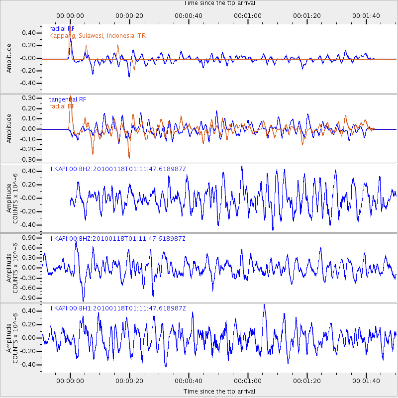
KAPI Kappang, Sulawesi, Indonesia - Earthquake Result Viewer
*The percent match for this event was below the threshold and hence no stack was calculated.
| Earthquake location: |
Kuril Islands |
| Earthquake latitude/longitude: |
46.5/153.3 |
| Earthquake time(UTC): |
2010/01/18 (018) 01:02:16 GMT |
| Earthquake Depth: |
7.0 km |
| Earthquake Magnitude: |
5.6 MB, 5.3 MS, 5.6 MW, 5.6 MW |
| Earthquake Catalog/Contributor: |
WHDF/NEIC |
|
| Network: |
II Global Seismograph Network (GSN - IRIS/IDA) |
| Station: |
KAPI Kappang, Sulawesi, Indonesia |
| Lat/Lon: |
5.01 S/119.75 E |
| Elevation: |
300 m |
|
| Distance: |
59.3 deg |
| Az: |
219.788 deg |
| Baz: |
26.352 deg |
| Ray Param: |
$rayparam |
*The percent match for this event was below the threshold and hence was not used in the summary stack. |
|
| Radial Match: |
59.42519 % |
| Radial Bump: |
400 |
| Transverse Match: |
54.97881 % |
| Transverse Bump: |
400 |
| SOD ConfigId: |
617450 |
| Insert Time: |
2013-09-30 22:13:54.802 +0000 |
| GWidth: |
2.5 |
| Max Bumps: |
400 |
| Tol: |
0.001 |
|
Signal To Noise
| Channel | StoN | STA | LTA |
| II:KAPI:00:BHZ:20100118T01:11:47.618987Z | 2.3061068 | 4.5703274E-7 | 1.9818368E-7 |
| II:KAPI:00:BH1:20100118T01:11:47.618987Z | 1.8763785 | 1.7267784E-7 | 9.202719E-8 |
| II:KAPI:00:BH2:20100118T01:11:47.618987Z | 1.196701 | 1.3569901E-7 | 1.1339424E-7 |
| Arrivals |
| Ps | |
| PpPs | |
| PsPs/PpSs | |


