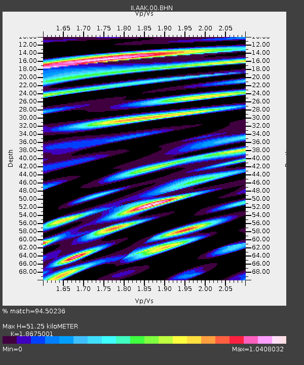
AAK Ala Archa, Kyrgyzstan - Earthquake Result Viewer

Earthquake location: Northern Sumatra, Indonesia
Earthquake latitude/longitude: 1.6/99.1
Earthquake time(UTC): 2008/05/19 (140) 14:26:45 GMT
Earthquake Depth: 10 km
Earthquake Magnitude: 5.8 MB, 6.0 MS, 6.0 MW, 6.0 MW
Earthquake Catalog/Contributor: WHDF/NEIC
Network: II Global Seismograph Network (GSN - IRIS/IDA)
Station: AAK Ala Archa, Kyrgyzstan
Lat/Lon: 42.64 N/74.49 E
Elevation: 1645 m
Distance: 46.4 deg
Az: 334.85 deg
Baz: 144.85 deg
Ray Param: 0.070664614
Estimated Moho Depth: 51.25 km
Estimated Crust Vp/Vs: 1.87
Assumed Crust Vp: 6.306 km/s
Estimated Crust Vs: 3.377 km/s
Estimated Crust Poisson's Ratio: 0.30
Radial Match: 94.50236 %
Radial Bump: 400
Transverse Match: 89.94895 %
Transverse Bump: 400
SOD ConfigId: 2504
Insert Time: 2010-03-01 15:30:06.173 +0000
GWidth: 2.5
Max Bumps: 400
Tol: 0.001

Signal To Noise

ChannelStoNSTALTA
II:AAK:00:BHN:20080519T14:34:40.698009Z20.075847.9536E-73.961777E-8
II:AAK:00:BHE:20080519T14:34:40.698009Z10.0144683.848094E-73.842535E-8
II:AAK:00:BHZ:20080519T14:34:40.698009Z14.87118153.96482E-72.6661096E-8
Arrivals
Ps7.5 SECOND
PpPs22 SECOND
PsPs/PpSs29 SECOND