You are here: Home > Network List > II - Global Seismograph Network (GSN - IRIS/IDA) Stations List
> Station KURK Kurchatov, Kazakhstan > Earthquake Result Viewer
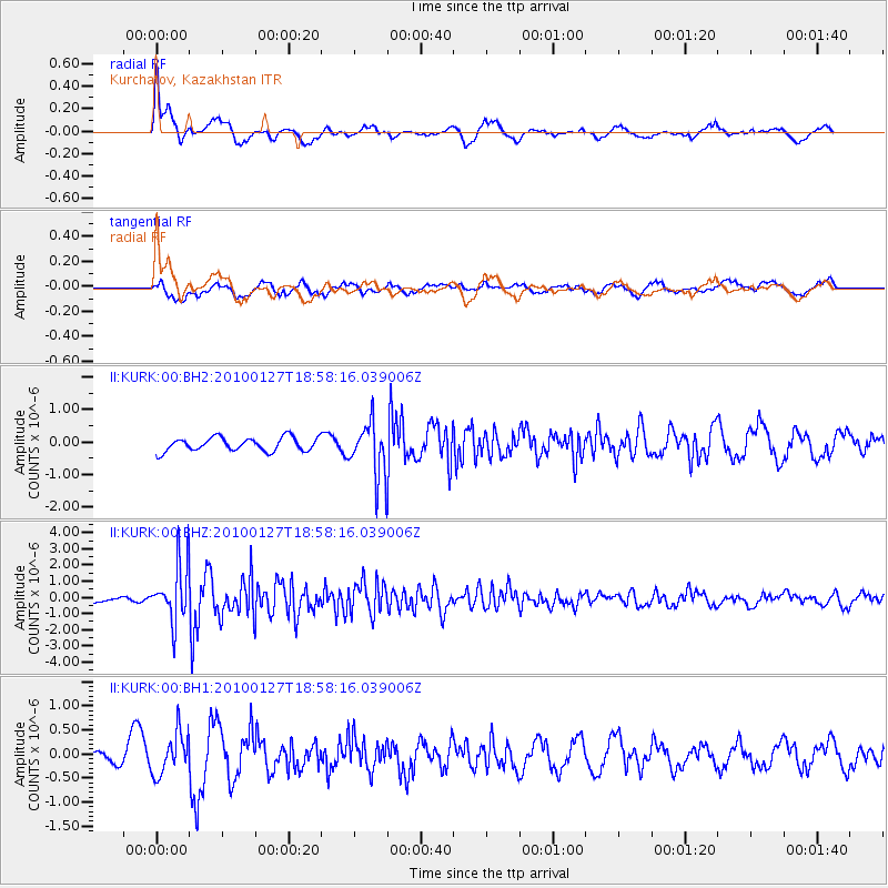
KURK Kurchatov, Kazakhstan - Earthquake Result Viewer
*The percent match for this event was below the threshold and hence no stack was calculated.
| Earthquake location: |
Philippine Islands Region |
| Earthquake latitude/longitude: |
13.6/125.5 |
| Earthquake time(UTC): |
2010/01/27 (027) 18:49:33 GMT |
| Earthquake Depth: |
29 km |
| Earthquake Magnitude: |
5.6 MB, 5.4 MS, 5.9 MW, 5.9 MW |
| Earthquake Catalog/Contributor: |
WHDF/NEIC |
|
| Network: |
II Global Seismograph Network (GSN - IRIS/IDA) |
| Station: |
KURK Kurchatov, Kazakhstan |
| Lat/Lon: |
50.72 N/78.62 E |
| Elevation: |
184 m |
|
| Distance: |
52.9 deg |
| Az: |
324.425 deg |
| Baz: |
117.169 deg |
| Ray Param: |
$rayparam |
*The percent match for this event was below the threshold and hence was not used in the summary stack. |
|
| Radial Match: |
51.081383 % |
| Radial Bump: |
400 |
| Transverse Match: |
44.31545 % |
| Transverse Bump: |
400 |
| SOD ConfigId: |
617450 |
| Insert Time: |
2013-09-30 22:43:45.789 +0000 |
| GWidth: |
2.5 |
| Max Bumps: |
400 |
| Tol: |
0.001 |
|
Signal To Noise
| Channel | StoN | STA | LTA |
| II:KURK:00:BHZ:20100127T18:58:16.039006Z | 8.569891 | 1.7558738E-6 | 2.0488869E-7 |
| II:KURK:00:BH1:20100127T18:58:16.039006Z | 2.4383008 | 4.3193887E-7 | 1.7714748E-7 |
| II:KURK:00:BH2:20100127T18:58:16.039006Z | 3.998781 | 8.36359E-7 | 2.0915348E-7 |
| Arrivals |
| Ps | |
| PpPs | |
| PsPs/PpSs | |


