You are here: Home > Network List > IU - Global Seismograph Network (GSN - IRIS/USGS) Stations List
> Station RSSD Black Hills, South Dakota, USA > Earthquake Result Viewer
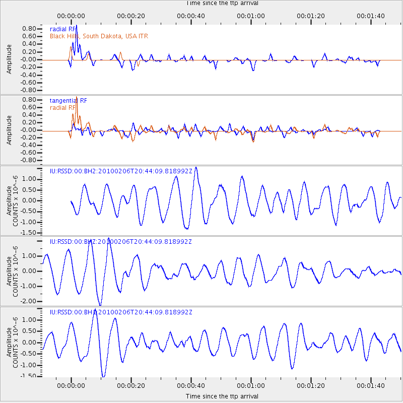
RSSD Black Hills, South Dakota, USA - Earthquake Result Viewer
*The percent match for this event was below the threshold and hence no stack was calculated.
| Earthquake location: |
Samoa Islands Region |
| Earthquake latitude/longitude: |
-16.0/-172.7 |
| Earthquake time(UTC): |
2010/02/06 (037) 20:31:58 GMT |
| Earthquake Depth: |
10 km |
| Earthquake Magnitude: |
5.5 MW, 5.6 MB |
| Earthquake Catalog/Contributor: |
NEIC PDE/NEIC PDE-M |
|
| Network: |
IU Global Seismograph Network (GSN - IRIS/USGS) |
| Station: |
RSSD Black Hills, South Dakota, USA |
| Lat/Lon: |
44.12 N/104.04 W |
| Elevation: |
2090 m |
|
| Distance: |
86.5 deg |
| Az: |
42.244 deg |
| Baz: |
243.863 deg |
| Ray Param: |
$rayparam |
*The percent match for this event was below the threshold and hence was not used in the summary stack. |
|
| Radial Match: |
87.118355 % |
| Radial Bump: |
400 |
| Transverse Match: |
81.092964 % |
| Transverse Bump: |
400 |
| SOD ConfigId: |
617450 |
| Insert Time: |
2013-09-30 23:03:53.395 +0000 |
| GWidth: |
2.5 |
| Max Bumps: |
400 |
| Tol: |
0.001 |
|
Signal To Noise
| Channel | StoN | STA | LTA |
| IU:RSSD:00:BHZ:20100206T20:44:09.818992Z | 1.9897244 | 1.021355E-6 | 5.1331483E-7 |
| IU:RSSD:00:BH1:20100206T20:44:09.818992Z | 2.1849055 | 6.4087124E-7 | 2.933176E-7 |
| IU:RSSD:00:BH2:20100206T20:44:09.818992Z | 1.3465191 | 6.587448E-7 | 4.8922055E-7 |
| Arrivals |
| Ps | |
| PpPs | |
| PsPs/PpSs | |


