You are here: Home > Network List > II - Global Seismograph Network (GSN - IRIS/IDA) Stations List
> Station PALK Pallekele, Sri Lanka > Earthquake Result Viewer
PALK Pallekele, Sri Lanka - Earthquake Result Viewer
| Earthquake location: |
Banda Sea |
| Earthquake latitude/longitude: |
-7.2/128.7 |
| Earthquake time(UTC): |
2010/02/15 (046) 21:51:47 GMT |
| Earthquake Depth: |
126 km |
| Earthquake Magnitude: |
6.4 MB, 6.2 MW, 6.2 MW |
| Earthquake Catalog/Contributor: |
WHDF/NEIC |
|
| Network: |
II Global Seismograph Network (GSN - IRIS/IDA) |
| Station: |
PALK Pallekele, Sri Lanka |
| Lat/Lon: |
7.27 N/80.70 E |
| Elevation: |
460 m |
|
| Distance: |
50.0 deg |
| Az: |
285.721 deg |
| Baz: |
105.696 deg |
| Ray Param: |
0.067903675 |
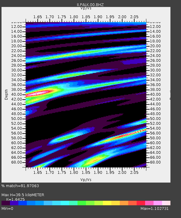
| Estimated Moho Depth: |
39.5 km |
| Estimated Crust Vp/Vs: |
1.64 |
| Assumed Crust Vp: |
6.545 km/s |
| Estimated Crust Vs: |
3.985 km/s |
| Estimated Crust Poisson's Ratio: |
0.21 |
|
| Radial Match: |
91.97063 % |
| Radial Bump: |
339 |
| Transverse Match: |
79.24243 % |
| Transverse Bump: |
400 |
| SOD ConfigId: |
617450 |
| Insert Time: |
2013-09-30 23:27:39.562 +0000 |
| GWidth: |
2.5 |
| Max Bumps: |
400 |
| Tol: |
0.001 |
|
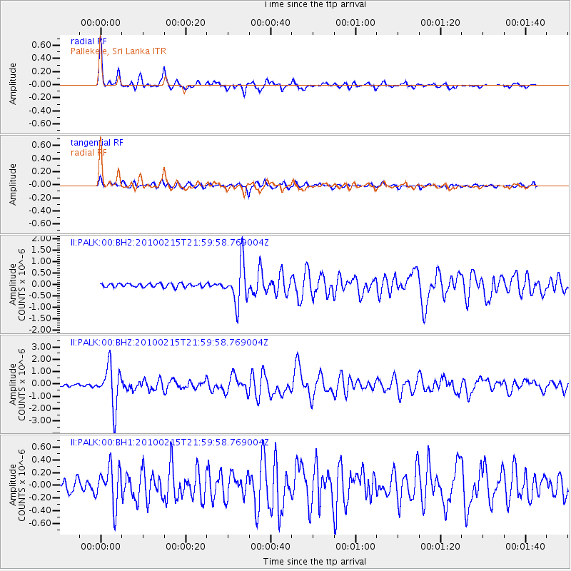
Signal To Noise
| Channel | StoN | STA | LTA |
| II:PALK:00:BHZ:20100215T21:59:58.769004Z | 16.192593 | 1.6840128E-6 | 1.0399896E-7 |
| II:PALK:00:BH1:20100215T21:59:58.769004Z | 4.0976 | 3.115113E-7 | 7.6022864E-8 |
| II:PALK:00:BH2:20100215T21:59:58.769004Z | 11.790637 | 9.013701E-7 | 7.6447954E-8 |
| Arrivals |
| Ps | 4.1 SECOND |
| PpPs | 15 SECOND |
| PsPs/PpSs | 19 SECOND |


