You are here: Home > Network List > II - Global Seismograph Network (GSN - IRIS/IDA) Stations List
> Station KAPI Kappang, Sulawesi, Indonesia > Earthquake Result Viewer
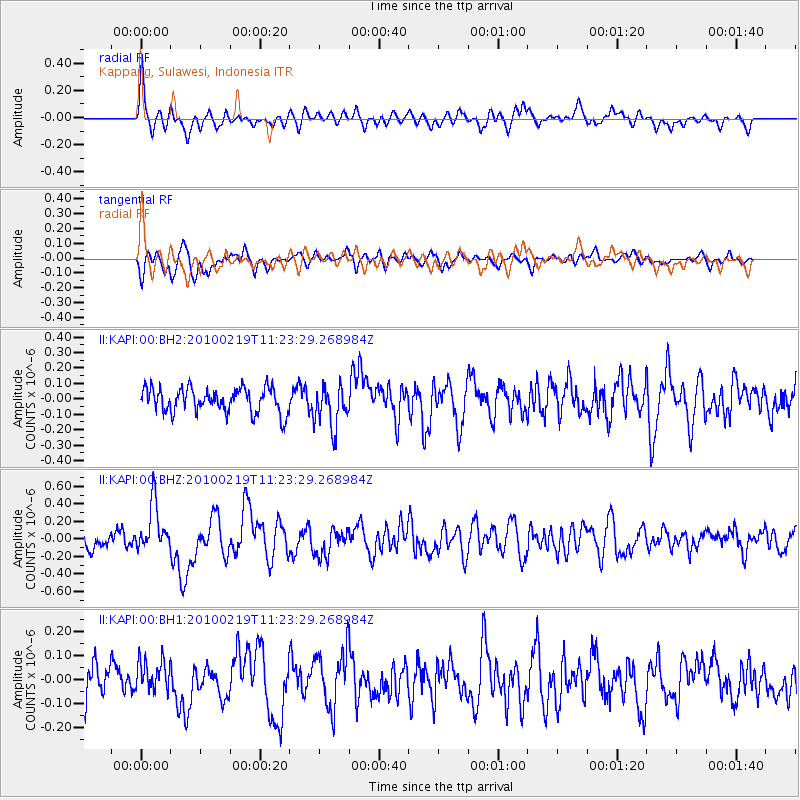
KAPI Kappang, Sulawesi, Indonesia - Earthquake Result Viewer
*The percent match for this event was below the threshold and hence no stack was calculated.
| Earthquake location: |
Tonga Islands |
| Earthquake latitude/longitude: |
-21.8/-175.1 |
| Earthquake time(UTC): |
2010/02/19 (050) 11:13:19 GMT |
| Earthquake Depth: |
10 km |
| Earthquake Magnitude: |
5.8 MW, 5.5 MS, 5.7 MW |
| Earthquake Catalog/Contributor: |
NEIC PDE/NEIC PDE-M |
|
| Network: |
II Global Seismograph Network (GSN - IRIS/IDA) |
| Station: |
KAPI Kappang, Sulawesi, Indonesia |
| Lat/Lon: |
5.01 S/119.75 E |
| Elevation: |
300 m |
|
| Distance: |
65.1 deg |
| Az: |
274.698 deg |
| Baz: |
111.647 deg |
| Ray Param: |
$rayparam |
*The percent match for this event was below the threshold and hence was not used in the summary stack. |
|
| Radial Match: |
70.11466 % |
| Radial Bump: |
400 |
| Transverse Match: |
66.38248 % |
| Transverse Bump: |
400 |
| SOD ConfigId: |
617450 |
| Insert Time: |
2013-09-30 23:32:38.060 +0000 |
| GWidth: |
2.5 |
| Max Bumps: |
400 |
| Tol: |
0.001 |
|
Signal To Noise
| Channel | StoN | STA | LTA |
| II:KAPI:00:BHZ:20100219T11:23:29.268984Z | 2.97244 | 2.752122E-7 | 9.2587975E-8 |
| II:KAPI:00:BH1:20100219T11:23:29.268984Z | 1.0320251 | 6.6534E-8 | 6.446936E-8 |
| II:KAPI:00:BH2:20100219T11:23:29.268984Z | 1.7252998 | 1.371933E-7 | 7.951853E-8 |
| Arrivals |
| Ps | |
| PpPs | |
| PsPs/PpSs | |


