You are here: Home > Network List > II - Global Seismograph Network (GSN - IRIS/IDA) Stations List
> Station MSEY Mahe, Seychelles > Earthquake Result Viewer
MSEY Mahe, Seychelles - Earthquake Result Viewer
| Earthquake location: |
Ryukyu Islands, Japan |
| Earthquake latitude/longitude: |
25.9/128.4 |
| Earthquake time(UTC): |
2010/02/26 (057) 20:31:26 GMT |
| Earthquake Depth: |
25 km |
| Earthquake Magnitude: |
7.0 MW, 6.7 MB, 7.0 MW, 7.0 MS |
| Earthquake Catalog/Contributor: |
NEIC PDE/NEIC PDE-M |
|
| Network: |
II Global Seismograph Network (GSN - IRIS/IDA) |
| Station: |
MSEY Mahe, Seychelles |
| Lat/Lon: |
4.67 S/55.48 E |
| Elevation: |
475 m |
|
| Distance: |
76.8 deg |
| Az: |
258.146 deg |
| Baz: |
62.15 deg |
| Ray Param: |
0.050708763 |
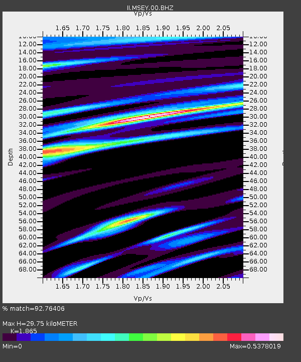
| Estimated Moho Depth: |
29.75 km |
| Estimated Crust Vp/Vs: |
1.87 |
| Assumed Crust Vp: |
6.303 km/s |
| Estimated Crust Vs: |
3.379 km/s |
| Estimated Crust Poisson's Ratio: |
0.30 |
|
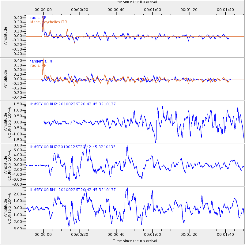
| Radial Match: |
92.76406 % |
| Radial Bump: |
348 |
| Transverse Match: |
87.29418 % |
| Transverse Bump: |
400 |
| SOD ConfigId: |
617450 |
| Insert Time: |
2013-09-30 23:52:16.322 +0000 |
| GWidth: |
2.5 |
| Max Bumps: |
400 |
| Tol: |
0.001 |
|
Signal To Noise
| Channel | StoN | STA | LTA |
| II:MSEY:00:BHZ:20100226T20:42:45.321013Z | 9.821884 | 1.5147779E-6 | 1.5422476E-7 |
| II:MSEY:00:BH1:20100226T20:42:45.321013Z | 3.2254045 | 5.800508E-7 | 1.7983817E-7 |
| II:MSEY:00:BH2:20100226T20:42:45.321013Z | 1.3690637 | 1.3758465E-7 | 1.00495434E-7 |
| Arrivals |
| Ps | 4.2 SECOND |
| PpPs | 13 SECOND |
| PsPs/PpSs | 17 SECOND |


