You are here: Home > Network List > II - Global Seismograph Network (GSN - IRIS/IDA) Stations List
> Station PALK Pallekele, Sri Lanka > Earthquake Result Viewer
PALK Pallekele, Sri Lanka - Earthquake Result Viewer
| Earthquake location: |
Ryukyu Islands, Japan |
| Earthquake latitude/longitude: |
25.9/128.4 |
| Earthquake time(UTC): |
2010/02/26 (057) 20:31:26 GMT |
| Earthquake Depth: |
25 km |
| Earthquake Magnitude: |
7.0 MW, 6.7 MB, 7.0 MW, 7.0 MS |
| Earthquake Catalog/Contributor: |
NEIC PDE/NEIC PDE-M |
|
| Network: |
II Global Seismograph Network (GSN - IRIS/IDA) |
| Station: |
PALK Pallekele, Sri Lanka |
| Lat/Lon: |
7.27 N/80.70 E |
| Elevation: |
460 m |
|
| Distance: |
49.0 deg |
| Az: |
256.443 deg |
| Baz: |
61.932 deg |
| Ray Param: |
0.068924114 |
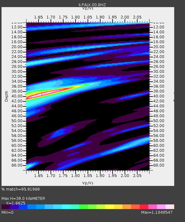
| Estimated Moho Depth: |
39.0 km |
| Estimated Crust Vp/Vs: |
1.66 |
| Assumed Crust Vp: |
6.545 km/s |
| Estimated Crust Vs: |
3.937 km/s |
| Estimated Crust Poisson's Ratio: |
0.22 |
|
| Radial Match: |
95.91969 % |
| Radial Bump: |
352 |
| Transverse Match: |
83.85349 % |
| Transverse Bump: |
400 |
| SOD ConfigId: |
617450 |
| Insert Time: |
2013-09-30 23:52:21.012 +0000 |
| GWidth: |
2.5 |
| Max Bumps: |
400 |
| Tol: |
0.001 |
|
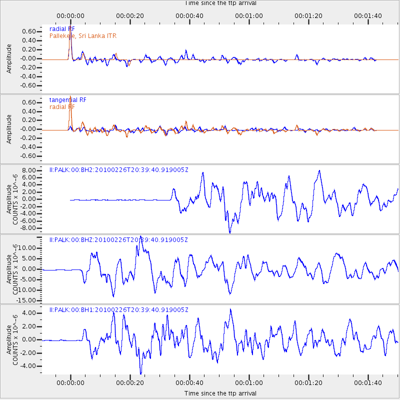
Signal To Noise
| Channel | StoN | STA | LTA |
| II:PALK:00:BHZ:20100226T20:39:40.919005Z | 24.168224 | 1.977448E-6 | 8.1820154E-8 |
| II:PALK:00:BH1:20100226T20:39:40.919005Z | 12.969431 | 5.4832924E-7 | 4.227859E-8 |
| II:PALK:00:BH2:20100226T20:39:40.919005Z | 30.718262 | 9.784054E-7 | 3.1850938E-8 |
| Arrivals |
| Ps | 4.2 SECOND |
| PpPs | 15 SECOND |
| PsPs/PpSs | 19 SECOND |


