You are here: Home > Network List > IU - Global Seismograph Network (GSN - IRIS/USGS) Stations List
> Station KEV Kevo, Finland > Earthquake Result Viewer
KEV Kevo, Finland - Earthquake Result Viewer
| Earthquake location: |
Ryukyu Islands, Japan |
| Earthquake latitude/longitude: |
25.9/128.4 |
| Earthquake time(UTC): |
2010/02/26 (057) 20:31:26 GMT |
| Earthquake Depth: |
25 km |
| Earthquake Magnitude: |
7.0 MW, 6.7 MB, 7.0 MW, 7.0 MS |
| Earthquake Catalog/Contributor: |
NEIC PDE/NEIC PDE-M |
|
| Network: |
IU Global Seismograph Network (GSN - IRIS/USGS) |
| Station: |
KEV Kevo, Finland |
| Lat/Lon: |
69.76 N/27.00 E |
| Elevation: |
100 m |
|
| Distance: |
69.8 deg |
| Az: |
338.68 deg |
| Baz: |
70.156 deg |
| Ray Param: |
0.055388097 |
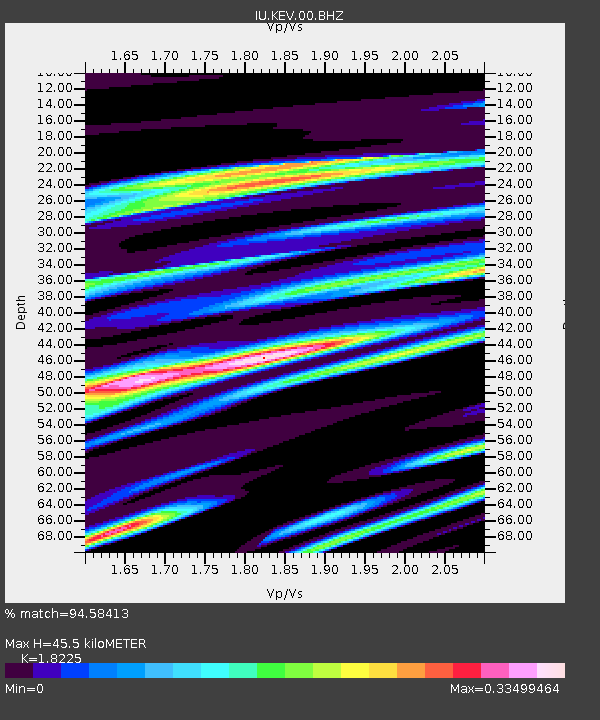
| Estimated Moho Depth: |
45.5 km |
| Estimated Crust Vp/Vs: |
1.82 |
| Assumed Crust Vp: |
6.622 km/s |
| Estimated Crust Vs: |
3.634 km/s |
| Estimated Crust Poisson's Ratio: |
0.28 |
|
| Radial Match: |
94.58413 % |
| Radial Bump: |
400 |
| Transverse Match: |
78.47307 % |
| Transverse Bump: |
400 |
| SOD ConfigId: |
617450 |
| Insert Time: |
2013-09-30 23:52:31.533 +0000 |
| GWidth: |
2.5 |
| Max Bumps: |
400 |
| Tol: |
0.001 |
|
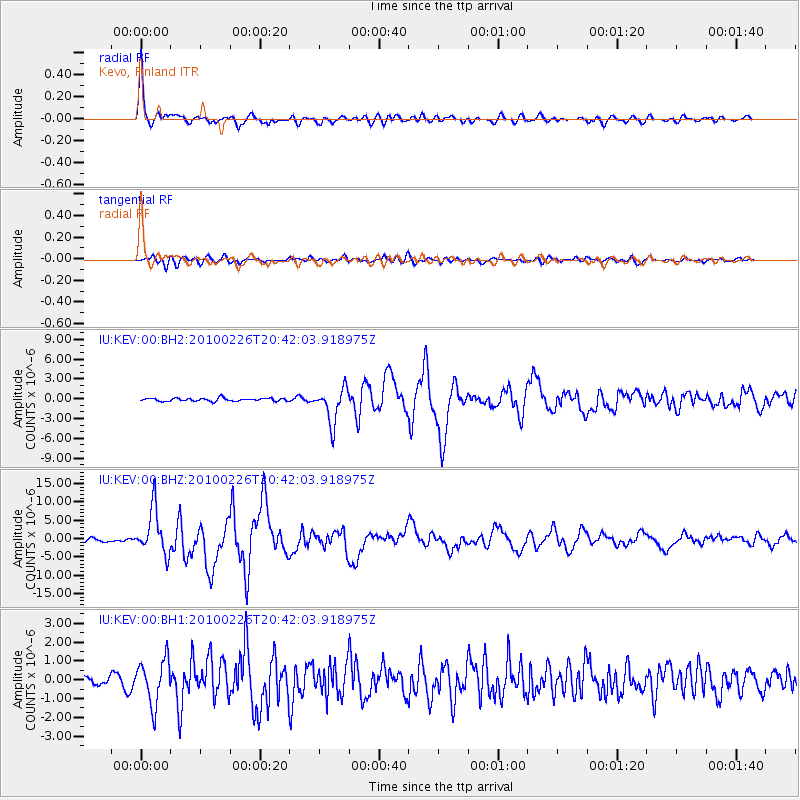
Signal To Noise
| Channel | StoN | STA | LTA |
| IU:KEV:00:BHZ:20100226T20:42:03.918975Z | 12.1786175 | 6.215476E-6 | 5.103597E-7 |
| IU:KEV:00:BH1:20100226T20:42:03.918975Z | 4.748405 | 1.1941426E-6 | 2.5148287E-7 |
| IU:KEV:00:BH2:20100226T20:42:03.918975Z | 11.422944 | 2.624542E-6 | 2.2976057E-7 |
| Arrivals |
| Ps | 5.9 SECOND |
| PpPs | 19 SECOND |
| PsPs/PpSs | 25 SECOND |


