You are here: Home > Network List > IU - Global Seismograph Network (GSN - IRIS/USGS) Stations List
> Station RSSD Black Hills, South Dakota, USA > Earthquake Result Viewer
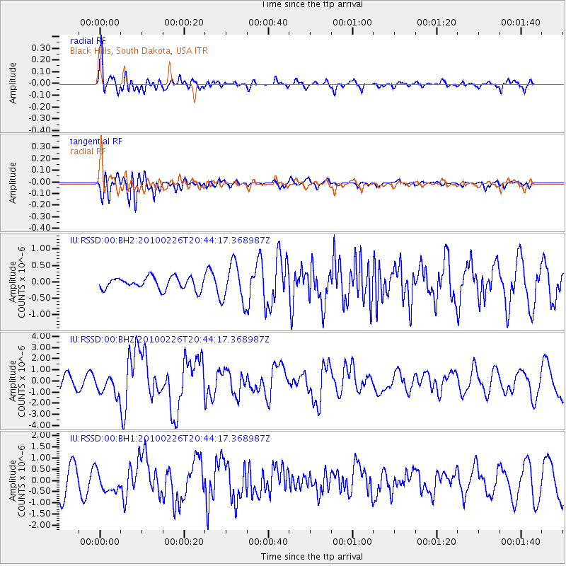
RSSD Black Hills, South Dakota, USA - Earthquake Result Viewer
*The percent match for this event was below the threshold and hence no stack was calculated.
| Earthquake location: |
Ryukyu Islands, Japan |
| Earthquake latitude/longitude: |
25.9/128.4 |
| Earthquake time(UTC): |
2010/02/26 (057) 20:31:26 GMT |
| Earthquake Depth: |
25 km |
| Earthquake Magnitude: |
7.0 MW, 6.7 MB, 7.0 MW, 7.0 MS |
| Earthquake Catalog/Contributor: |
NEIC PDE/NEIC PDE-M |
|
| Network: |
IU Global Seismograph Network (GSN - IRIS/USGS) |
| Station: |
RSSD Black Hills, South Dakota, USA |
| Lat/Lon: |
44.12 N/104.04 W |
| Elevation: |
2090 m |
|
| Distance: |
95.4 deg |
| Az: |
35.001 deg |
| Baz: |
314.179 deg |
| Ray Param: |
$rayparam |
*The percent match for this event was below the threshold and hence was not used in the summary stack. |
|
| Radial Match: |
78.15635 % |
| Radial Bump: |
400 |
| Transverse Match: |
74.6613 % |
| Transverse Bump: |
400 |
| SOD ConfigId: |
617450 |
| Insert Time: |
2013-09-30 23:52:36.347 +0000 |
| GWidth: |
2.5 |
| Max Bumps: |
400 |
| Tol: |
0.001 |
|
Signal To Noise
| Channel | StoN | STA | LTA |
| IU:RSSD:00:BHZ:20100226T20:44:17.368987Z | 1.2988441 | 9.1527085E-7 | 7.046811E-7 |
| IU:RSSD:00:BH1:20100226T20:44:17.368987Z | 0.625395 | 4.4703134E-7 | 7.147984E-7 |
| IU:RSSD:00:BH2:20100226T20:44:17.368987Z | 3.2487833 | 5.9494994E-7 | 1.8313007E-7 |
| Arrivals |
| Ps | |
| PpPs | |
| PsPs/PpSs | |


