You are here: Home > Network List > CU - Caribbean Network (USGS) Stations List
> Station BBGH Gun Hill, Barbados > Earthquake Result Viewer
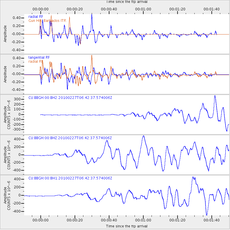
BBGH Gun Hill, Barbados - Earthquake Result Viewer
*The percent match for this event was below the threshold and hence no stack was calculated.
| Earthquake location: |
Near Coast Of Central Chile |
| Earthquake latitude/longitude: |
-36.1/-72.9 |
| Earthquake time(UTC): |
2010/02/27 (058) 06:34:11 GMT |
| Earthquake Depth: |
23 km |
| Earthquake Magnitude: |
8.8 MW, 7.2 MB, 8.5 MS, 8.8 MW |
| Earthquake Catalog/Contributor: |
NEIC PDE/NEIC PDE-M |
|
| Network: |
CU Caribbean Network (USGS) |
| Station: |
BBGH Gun Hill, Barbados |
| Lat/Lon: |
13.14 N/59.56 W |
| Elevation: |
180 m |
|
| Distance: |
50.6 deg |
| Az: |
16.91 deg |
| Baz: |
193.99 deg |
| Ray Param: |
$rayparam |
*The percent match for this event was below the threshold and hence was not used in the summary stack. |
|
| Radial Match: |
93.13522 % |
| Radial Bump: |
400 |
| Transverse Match: |
89.508896 % |
| Transverse Bump: |
400 |
| SOD ConfigId: |
617450 |
| Insert Time: |
2013-09-30 23:53:50.897 +0000 |
| GWidth: |
2.5 |
| Max Bumps: |
400 |
| Tol: |
0.001 |
|
Signal To Noise
| Channel | StoN | STA | LTA |
| CU:BBGH:00:BHZ:20100227T06:42:37.574006Z | 2.40817 | 5.350813E-6 | 2.2219415E-6 |
| CU:BBGH:00:BH1:20100227T06:42:37.574006Z | 1.8890892 | 4.5262304E-6 | 2.3959856E-6 |
| CU:BBGH:00:BH2:20100227T06:42:37.574006Z | 0.88035095 | 2.0909165E-6 | 2.3750943E-6 |
| Arrivals |
| Ps | |
| PpPs | |
| PsPs/PpSs | |


