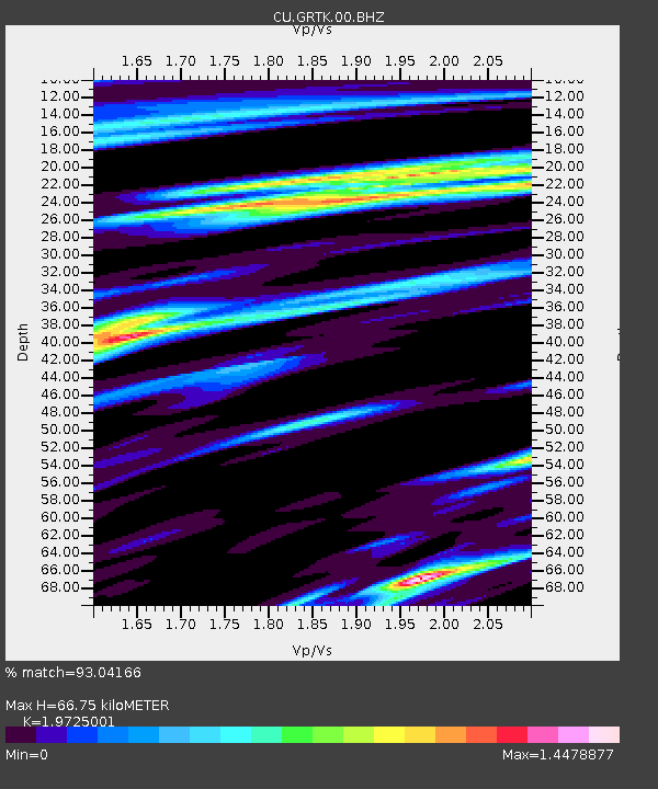
GRTK Grand Turk, Turks and Caicos Islands - Earthquake Result Viewer

Earthquake location: Near Coast Of Central Chile
Earthquake latitude/longitude: -36.1/-72.9
Earthquake time(UTC): 2010/02/27 (058) 06:34:11 GMT
Earthquake Depth: 23 km
Earthquake Magnitude: 8.8 MW, 7.2 MB, 8.5 MS, 8.8 MW
Earthquake Catalog/Contributor: NEIC PDE/NEIC PDE-M
Network: CU Caribbean Network (USGS)
Station: GRTK Grand Turk, Turks and Caicos Islands
Lat/Lon: 21.51 N/71.13 W
Elevation: 12 m
Distance: 57.3 deg
Az: 1.953 deg
Baz: 181.698 deg
Ray Param: 0.063520305
Estimated Moho Depth: 66.75 km
Estimated Crust Vp/Vs: 1.97
Assumed Crust Vp: 4.452 km/s
Estimated Crust Vs: 2.257 km/s
Estimated Crust Poisson's Ratio: 0.33
Radial Match: 93.04166 %
Radial Bump: 332
Transverse Match: 91.12978 %
Transverse Bump: 400
SOD ConfigId: 617450
Insert Time: 2013-09-30 23:54:00.841 +0000
GWidth: 2.5
Max Bumps: 400
Tol: 0.001

Signal To Noise

ChannelStoNSTALTA
CU:GRTK:00:BHZ:20100227T06:43:26.774995Z2.02702673.4707873E-61.7122553E-6
CU:GRTK:00:BH1:20100227T06:43:26.774995Z1.27253931.7880122E-61.4050744E-6
CU:GRTK:00:BH2:20100227T06:43:26.774995Z0.74883356.1324226E-78.1893006E-7
Arrivals
Ps15 SECOND
PpPs44 SECOND
PsPs/PpSs59 SECOND