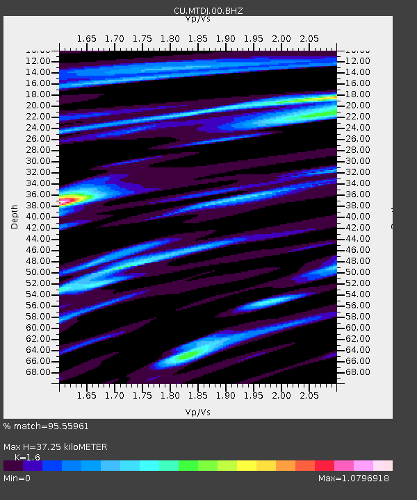
MTDJ Mount Denham, Jamaica - Earthquake Result Viewer

Earthquake location: Near Coast Of Central Chile
Earthquake latitude/longitude: -36.1/-72.9
Earthquake time(UTC): 2010/02/27 (058) 06:34:11 GMT
Earthquake Depth: 23 km
Earthquake Magnitude: 8.8 MW, 7.2 MB, 8.5 MS, 8.8 MW
Earthquake Catalog/Contributor: NEIC PDE/NEIC PDE-M
Network: CU Caribbean Network (USGS)
Station: MTDJ Mount Denham, Jamaica
Lat/Lon: 18.23 N/77.53 W
Elevation: 925 m
Distance: 54.2 deg
Az: 354.566 deg
Baz: 175.373 deg
Ray Param: 0.06554752
Estimated Moho Depth: 37.25 km
Estimated Crust Vp/Vs: 1.60
Assumed Crust Vp: 4.662 km/s
Estimated Crust Vs: 2.914 km/s
Estimated Crust Poisson's Ratio: 0.18
Radial Match: 95.55961 %
Radial Bump: 399
Transverse Match: 84.18828 %
Transverse Bump: 400
SOD ConfigId: 617450
Insert Time: 2013-09-30 23:54:05.943 +0000
GWidth: 2.5
Max Bumps: 400
Tol: 0.001

Signal To Noise

ChannelStoNSTALTA
CU:MTDJ:00:BHZ:20100227T06:43:04.475007Z2.1241061.8071519E-68.507823E-7
CU:MTDJ:00:BH1:20100227T06:43:04.475007Z1.37885081.1150389E-68.086726E-7
CU:MTDJ:00:BH2:20100227T06:43:04.475007Z1.23608411.1053357E-68.942237E-7
Arrivals
Ps4.9 SECOND
PpPs20 SECOND
PsPs/PpSs25 SECOND