You are here: Home > Network List > IU - Global Seismograph Network (GSN - IRIS/USGS) Stations List
> Station ANMO Albuquerque, New Mexico, USA > Earthquake Result Viewer
ANMO Albuquerque, New Mexico, USA - Earthquake Result Viewer
| Earthquake location: |
Near Coast Of Central Chile |
| Earthquake latitude/longitude: |
-36.1/-72.9 |
| Earthquake time(UTC): |
2010/02/27 (058) 06:34:11 GMT |
| Earthquake Depth: |
23 km |
| Earthquake Magnitude: |
8.8 MW, 7.2 MB, 8.5 MS, 8.8 MW |
| Earthquake Catalog/Contributor: |
NEIC PDE/NEIC PDE-M |
|
| Network: |
IU Global Seismograph Network (GSN - IRIS/USGS) |
| Station: |
ANMO Albuquerque, New Mexico, USA |
| Lat/Lon: |
34.95 N/106.46 W |
| Elevation: |
1820 m |
|
| Distance: |
77.3 deg |
| Az: |
332.259 deg |
| Baz: |
152.693 deg |
| Ray Param: |
0.050380636 |
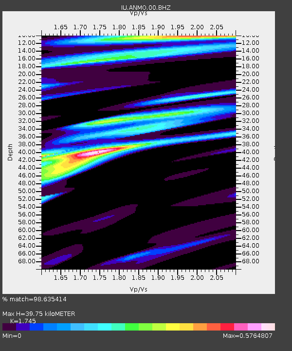
| Estimated Moho Depth: |
39.75 km |
| Estimated Crust Vp/Vs: |
1.75 |
| Assumed Crust Vp: |
6.502 km/s |
| Estimated Crust Vs: |
3.726 km/s |
| Estimated Crust Poisson's Ratio: |
0.26 |
|
| Radial Match: |
98.635414 % |
| Radial Bump: |
261 |
| Transverse Match: |
92.45463 % |
| Transverse Bump: |
400 |
| SOD ConfigId: |
617450 |
| Insert Time: |
2013-09-30 23:54:22.046 +0000 |
| GWidth: |
2.5 |
| Max Bumps: |
400 |
| Tol: |
0.001 |
|

Signal To Noise
| Channel | StoN | STA | LTA |
| IU:ANMO:00:BHZ:20100227T06:45:32.918977Z | 1.7550159 | 9.012551E-7 | 5.1353106E-7 |
| IU:ANMO:00:BH1:20100227T06:45:32.918977Z | 2.3412673 | 8.6683747E-7 | 3.7024284E-7 |
| IU:ANMO:00:BH2:20100227T06:45:32.918977Z | 0.75166124 | 1.8230784E-7 | 2.425399E-7 |
| Arrivals |
| Ps | 4.7 SECOND |
| PpPs | 16 SECOND |
| PsPs/PpSs | 21 SECOND |


