You are here: Home > Network List > IU - Global Seismograph Network (GSN - IRIS/USGS) Stations List
> Station TEIG Tepich, Yucatan, Mexico > Earthquake Result Viewer
TEIG Tepich, Yucatan, Mexico - Earthquake Result Viewer
| Earthquake location: |
Near Coast Of Central Chile |
| Earthquake latitude/longitude: |
-36.1/-72.9 |
| Earthquake time(UTC): |
2010/02/27 (058) 06:34:11 GMT |
| Earthquake Depth: |
23 km |
| Earthquake Magnitude: |
8.8 MW, 7.2 MB, 8.5 MS, 8.8 MW |
| Earthquake Catalog/Contributor: |
NEIC PDE/NEIC PDE-M |
|
| Network: |
IU Global Seismograph Network (GSN - IRIS/USGS) |
| Station: |
TEIG Tepich, Yucatan, Mexico |
| Lat/Lon: |
20.23 N/88.28 W |
| Elevation: |
40 m |
|
| Distance: |
57.9 deg |
| Az: |
342.904 deg |
| Baz: |
165.318 deg |
| Ray Param: |
0.06316349 |
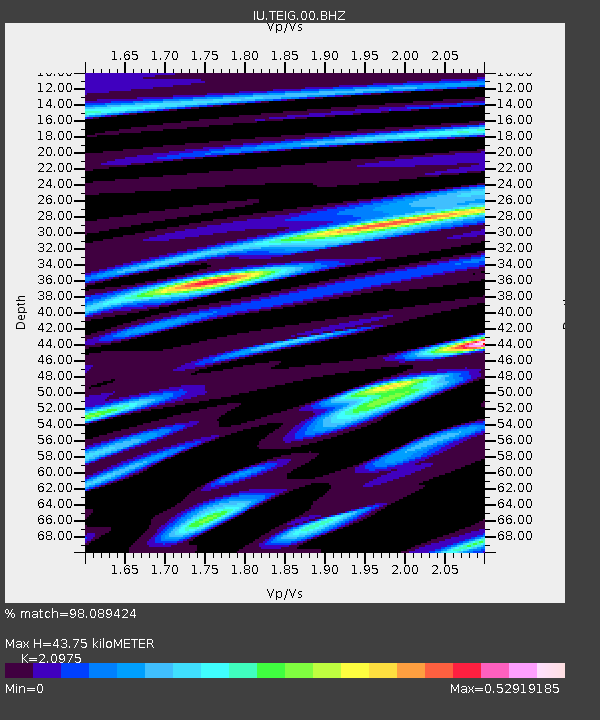
| Estimated Moho Depth: |
43.75 km |
| Estimated Crust Vp/Vs: |
2.10 |
| Assumed Crust Vp: |
5.817 km/s |
| Estimated Crust Vs: |
2.773 km/s |
| Estimated Crust Poisson's Ratio: |
0.35 |
|
| Radial Match: |
98.089424 % |
| Radial Bump: |
248 |
| Transverse Match: |
98.0947 % |
| Transverse Bump: |
258 |
| SOD ConfigId: |
617450 |
| Insert Time: |
2013-09-30 23:54:33.377 +0000 |
| GWidth: |
2.5 |
| Max Bumps: |
400 |
| Tol: |
0.001 |
|

Signal To Noise
| Channel | StoN | STA | LTA |
| IU:TEIG:00:BHZ:20100227T06:43:30.704988Z | 1.8431805 | 1.7290648E-6 | 9.380876E-7 |
| IU:TEIG:00:BH1:20100227T06:43:30.704988Z | 0.8284758 | 2.0683088E-7 | 2.496523E-7 |
| IU:TEIG:00:BH2:20100227T06:43:30.704988Z | 1.3265563 | 1.0559763E-6 | 7.960283E-7 |
| Arrivals |
| Ps | 8.5 SECOND |
| PpPs | 23 SECOND |
| PsPs/PpSs | 31 SECOND |


