You are here: Home > Network List > US - United States National Seismic Network Stations List
> Station KSU1 Kansas State University--Konza Prairie, Kansas, USA > Earthquake Result Viewer
KSU1 Kansas State University--Konza Prairie, Kansas, USA - Earthquake Result Viewer
| Earthquake location: |
Near Coast Of Central Chile |
| Earthquake latitude/longitude: |
-36.1/-72.9 |
| Earthquake time(UTC): |
2010/02/27 (058) 06:34:11 GMT |
| Earthquake Depth: |
23 km |
| Earthquake Magnitude: |
8.8 MW, 7.2 MB, 8.5 MS, 8.8 MW |
| Earthquake Catalog/Contributor: |
NEIC PDE/NEIC PDE-M |
|
| Network: |
US United States National Seismic Network |
| Station: |
KSU1 Kansas State University--Konza Prairie, Kansas, USA |
| Lat/Lon: |
39.10 N/96.61 W |
| Elevation: |
347 m |
|
| Distance: |
78.0 deg |
| Az: |
341.343 deg |
| Baz: |
160.557 deg |
| Ray Param: |
0.04992414 |
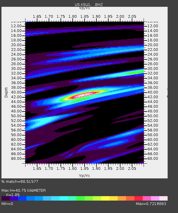
| Estimated Moho Depth: |
40.75 km |
| Estimated Crust Vp/Vs: |
1.85 |
| Assumed Crust Vp: |
6.483 km/s |
| Estimated Crust Vs: |
3.504 km/s |
| Estimated Crust Poisson's Ratio: |
0.29 |
|
| Radial Match: |
98.51577 % |
| Radial Bump: |
262 |
| Transverse Match: |
89.91868 % |
| Transverse Bump: |
400 |
| SOD ConfigId: |
617450 |
| Insert Time: |
2013-09-30 23:54:42.762 +0000 |
| GWidth: |
2.5 |
| Max Bumps: |
400 |
| Tol: |
0.001 |
|

Signal To Noise
| Channel | StoN | STA | LTA |
| US:KSU1: :BHZ:20100227T06:45:36.624971Z | 2.9847198 | 1.9126298E-6 | 6.408072E-7 |
| US:KSU1: :BH1:20100227T06:45:36.624971Z | 0.79671395 | 4.2290236E-7 | 5.308083E-7 |
| US:KSU1: :BH2:20100227T06:45:36.624971Z | 0.9008073 | 4.7176465E-7 | 5.237132E-7 |
| Arrivals |
| Ps | 5.5 SECOND |
| PpPs | 17 SECOND |
| PsPs/PpSs | 23 SECOND |


