You are here: Home > Network List > CI - Caltech Regional Seismic Network Stations List
> Station TIN Tinemaha, California, USA > Earthquake Result Viewer
TIN Tinemaha, California, USA - Earthquake Result Viewer
| Earthquake location: |
Near East Coast Of Honshu, Japan |
| Earthquake latitude/longitude: |
38.8/141.6 |
| Earthquake time(UTC): |
2003/05/26 (146) 09:24:33 GMT |
| Earthquake Depth: |
68 km |
| Earthquake Magnitude: |
6.7 MB, 7.0 MW, 7.0 MW |
| Earthquake Catalog/Contributor: |
WHDF/NEIC |
|
| Network: |
CI Caltech Regional Seismic Network |
| Station: |
TIN Tinemaha, California, USA |
| Lat/Lon: |
37.05 N/118.23 W |
| Elevation: |
1164 m |
|
| Distance: |
74.7 deg |
| Az: |
54.722 deg |
| Baz: |
307.173 deg |
| Ray Param: |
0.052023895 |
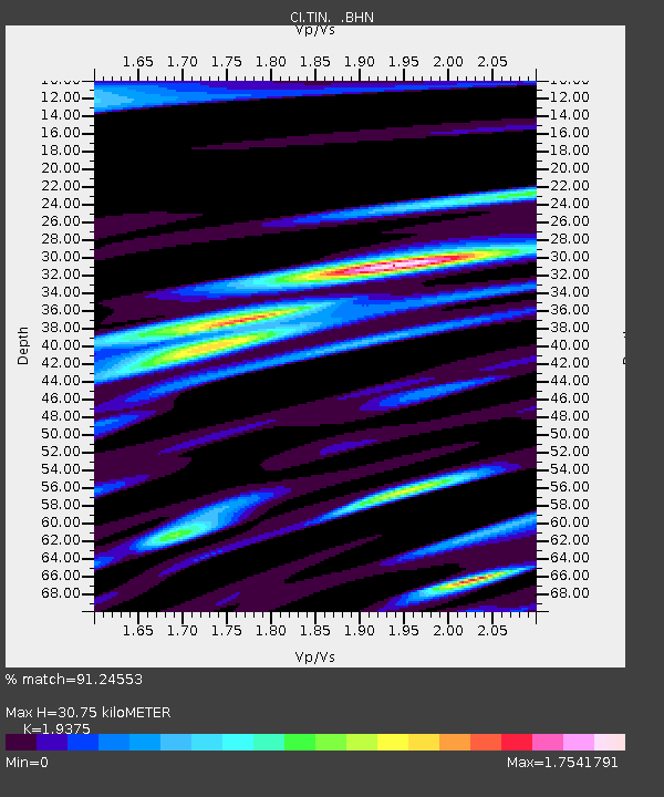
| Estimated Moho Depth: |
30.75 km |
| Estimated Crust Vp/Vs: |
1.94 |
| Assumed Crust Vp: |
6.291 km/s |
| Estimated Crust Vs: |
3.247 km/s |
| Estimated Crust Poisson's Ratio: |
0.32 |
|
| Radial Match: |
91.24553 % |
| Radial Bump: |
400 |
| Transverse Match: |
88.46645 % |
| Transverse Bump: |
400 |
| SOD ConfigId: |
3787 |
| Insert Time: |
2010-02-25 20:47:41.445 +0000 |
| GWidth: |
2.5 |
| Max Bumps: |
400 |
| Tol: |
0.001 |
|
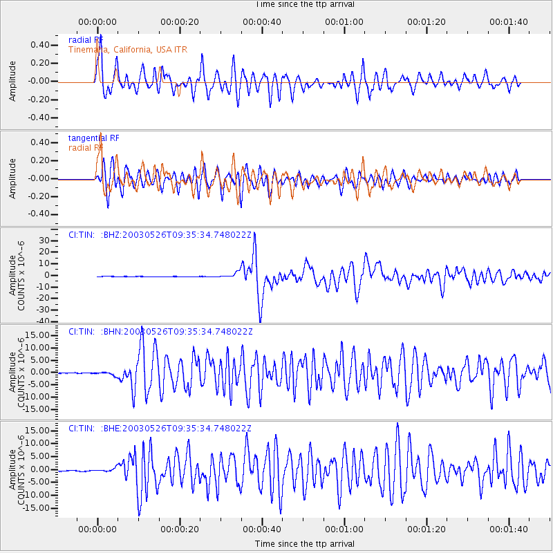
Signal To Noise
| Channel | StoN | STA | LTA |
| CI:TIN: :BHN:20030526T09:35:34.748022Z | 2.9121125 | 7.5334515E-7 | 2.586937E-7 |
| CI:TIN: :BHE:20030526T09:35:34.748022Z | 5.371735 | 7.990686E-7 | 1.4875428E-7 |
| CI:TIN: :BHZ:20030526T09:35:34.748022Z | 19.457722 | 2.6257264E-6 | 1.3494521E-7 |
| Arrivals |
| Ps | 4.7 SECOND |
| PpPs | 14 SECOND |
| PsPs/PpSs | 19 SECOND |


