You are here: Home > Network List > TA - USArray Transportable Network (new EarthScope stations) Stations List
> Station D62A Allapoint, Allagash, ME, USA > Earthquake Result Viewer
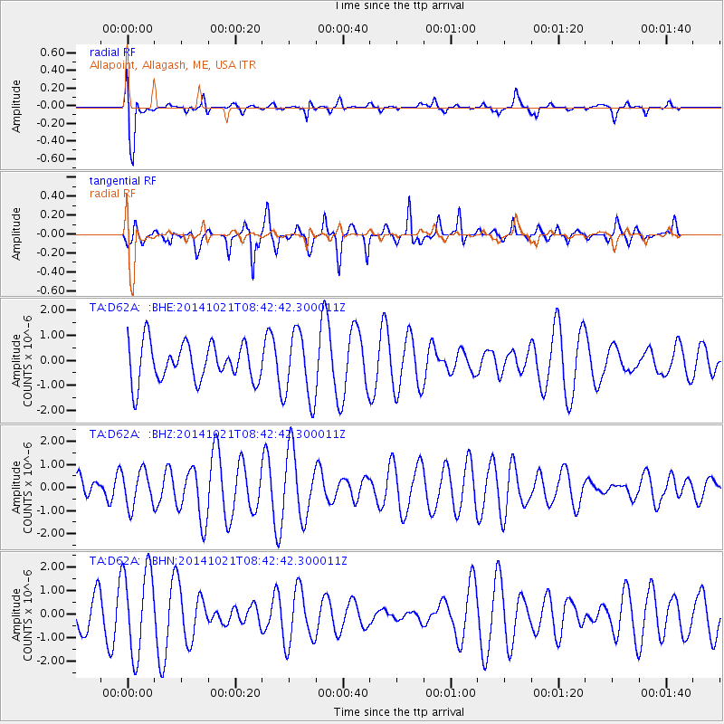
D62A Allapoint, Allagash, ME, USA - Earthquake Result Viewer
*The percent match for this event was below the threshold and hence no stack was calculated.
| Earthquake location: |
Iceland |
| Earthquake latitude/longitude: |
64.7/-17.3 |
| Earthquake time(UTC): |
2014/10/21 (294) 08:36:39 GMT |
| Earthquake Depth: |
3.1 km |
| Earthquake Magnitude: |
5.4 MW |
| Earthquake Catalog/Contributor: |
ISC/ISC |
|
| Network: |
TA USArray Transportable Network (new EarthScope stations) |
| Station: |
D62A Allapoint, Allagash, ME, USA |
| Lat/Lon: |
47.08 N/69.05 W |
| Elevation: |
189 m |
|
| Distance: |
32.7 deg |
| Az: |
262.79 deg |
| Baz: |
38.65 deg |
| Ray Param: |
$rayparam |
*The percent match for this event was below the threshold and hence was not used in the summary stack. |
|
| Radial Match: |
77.90991 % |
| Radial Bump: |
400 |
| Transverse Match: |
46.006252 % |
| Transverse Bump: |
311 |
| SOD ConfigId: |
3390531 |
| Insert Time: |
2019-04-14 16:06:28.647 +0000 |
| GWidth: |
2.5 |
| Max Bumps: |
400 |
| Tol: |
0.001 |
|
Signal To Noise
| Channel | StoN | STA | LTA |
| TA:D62A: :BHZ:20141021T08:42:42.300011Z | 0.9840003 | 7.7017023E-7 | 7.8269306E-7 |
| TA:D62A: :BHN:20141021T08:42:42.300011Z | 2.5133908 | 1.813825E-6 | 7.216645E-7 |
| TA:D62A: :BHE:20141021T08:42:42.300011Z | 1.7965264 | 1.3550815E-6 | 7.5427863E-7 |
| Arrivals |
| Ps | |
| PpPs | |
| PsPs/PpSs | |


