You are here: Home > Network List > CU - Caribbean Network (USGS) Stations List
> Station BBGH Gun Hill, Barbados > Earthquake Result Viewer
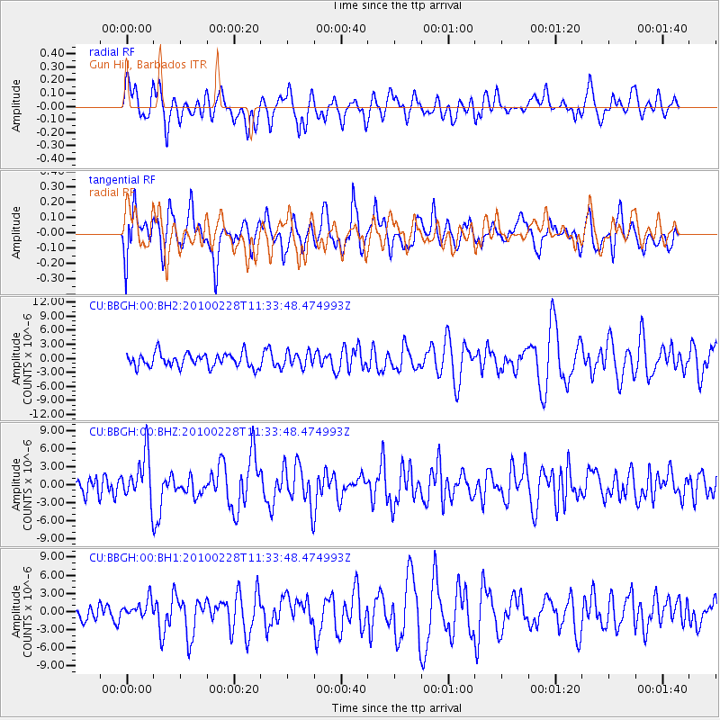
BBGH Gun Hill, Barbados - Earthquake Result Viewer
*The percent match for this event was below the threshold and hence no stack was calculated.
| Earthquake location: |
Near Coast Of Central Chile |
| Earthquake latitude/longitude: |
-34.9/-71.6 |
| Earthquake time(UTC): |
2010/02/28 (059) 11:25:35 GMT |
| Earthquake Depth: |
46 km |
| Earthquake Magnitude: |
6.2 MW, 5.8 MS, 6.2 MB, 6.2 MW |
| Earthquake Catalog/Contributor: |
NEIC PDE/NEIC PDE-M |
|
| Network: |
CU Caribbean Network (USGS) |
| Station: |
BBGH Gun Hill, Barbados |
| Lat/Lon: |
13.14 N/59.56 W |
| Elevation: |
180 m |
|
| Distance: |
49.1 deg |
| Az: |
15.611 deg |
| Baz: |
193.123 deg |
| Ray Param: |
$rayparam |
*The percent match for this event was below the threshold and hence was not used in the summary stack. |
|
| Radial Match: |
58.909763 % |
| Radial Bump: |
400 |
| Transverse Match: |
56.592846 % |
| Transverse Bump: |
400 |
| SOD ConfigId: |
617450 |
| Insert Time: |
2013-10-01 01:02:22.753 +0000 |
| GWidth: |
2.5 |
| Max Bumps: |
400 |
| Tol: |
0.001 |
|
Signal To Noise
| Channel | StoN | STA | LTA |
| CU:BBGH:00:BHZ:20100228T11:33:48.474993Z | 3.484733 | 3.9639103E-6 | 1.1375076E-6 |
| CU:BBGH:00:BH1:20100228T11:33:48.474993Z | 1.257729 | 1.5535757E-6 | 1.2352228E-6 |
| CU:BBGH:00:BH2:20100228T11:33:48.474993Z | 1.0760092 | 1.589015E-6 | 1.4767672E-6 |
| Arrivals |
| Ps | |
| PpPs | |
| PsPs/PpSs | |


