You are here: Home > Network List > IU - Global Seismograph Network (GSN - IRIS/USGS) Stations List
> Station RSSD Black Hills, South Dakota, USA > Earthquake Result Viewer
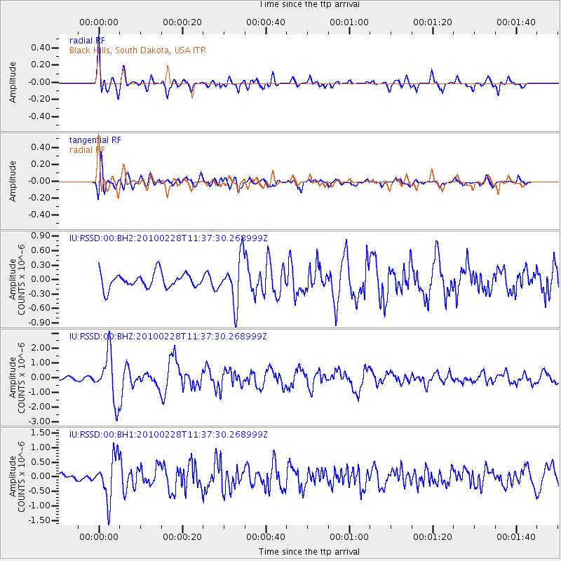
RSSD Black Hills, South Dakota, USA - Earthquake Result Viewer
*The percent match for this event was below the threshold and hence no stack was calculated.
| Earthquake location: |
Near Coast Of Central Chile |
| Earthquake latitude/longitude: |
-34.9/-71.6 |
| Earthquake time(UTC): |
2010/02/28 (059) 11:25:35 GMT |
| Earthquake Depth: |
46 km |
| Earthquake Magnitude: |
6.2 MW, 5.8 MS, 6.2 MB, 6.2 MW |
| Earthquake Catalog/Contributor: |
NEIC PDE/NEIC PDE-M |
|
| Network: |
IU Global Seismograph Network (GSN - IRIS/USGS) |
| Station: |
RSSD Black Hills, South Dakota, USA |
| Lat/Lon: |
44.12 N/104.04 W |
| Elevation: |
2090 m |
|
| Distance: |
84.0 deg |
| Az: |
337.156 deg |
| Baz: |
153.701 deg |
| Ray Param: |
$rayparam |
*The percent match for this event was below the threshold and hence was not used in the summary stack. |
|
| Radial Match: |
73.35177 % |
| Radial Bump: |
400 |
| Transverse Match: |
77.78747 % |
| Transverse Bump: |
400 |
| SOD ConfigId: |
617450 |
| Insert Time: |
2013-10-01 01:03:06.455 +0000 |
| GWidth: |
2.5 |
| Max Bumps: |
400 |
| Tol: |
0.001 |
|
Signal To Noise
| Channel | StoN | STA | LTA |
| IU:RSSD:00:BHZ:20100228T11:37:30.268999Z | 11.595932 | 1.6641031E-6 | 1.4350749E-7 |
| IU:RSSD:00:BH1:20100228T11:37:30.268999Z | 4.46435 | 7.457951E-7 | 1.6705569E-7 |
| IU:RSSD:00:BH2:20100228T11:37:30.268999Z | 3.240833 | 4.96331E-7 | 1.531492E-7 |
| Arrivals |
| Ps | |
| PpPs | |
| PsPs/PpSs | |


