You are here: Home > Network List > II - Global Seismograph Network (GSN - IRIS/IDA) Stations List
> Station PALK Pallekele, Sri Lanka > Earthquake Result Viewer
PALK Pallekele, Sri Lanka - Earthquake Result Viewer
| Earthquake location: |
Taiwan |
| Earthquake latitude/longitude: |
22.9/120.8 |
| Earthquake time(UTC): |
2010/03/04 (063) 00:18:51 GMT |
| Earthquake Depth: |
21 km |
| Earthquake Magnitude: |
6.2 MB, 6.2 MS, 6.3 MW, 6.2 MW |
| Earthquake Catalog/Contributor: |
WHDF/NEIC |
|
| Network: |
II Global Seismograph Network (GSN - IRIS/IDA) |
| Station: |
PALK Pallekele, Sri Lanka |
| Lat/Lon: |
7.27 N/80.70 E |
| Elevation: |
460 m |
|
| Distance: |
41.5 deg |
| Az: |
254.44 deg |
| Baz: |
63.549 deg |
| Ray Param: |
0.073694095 |
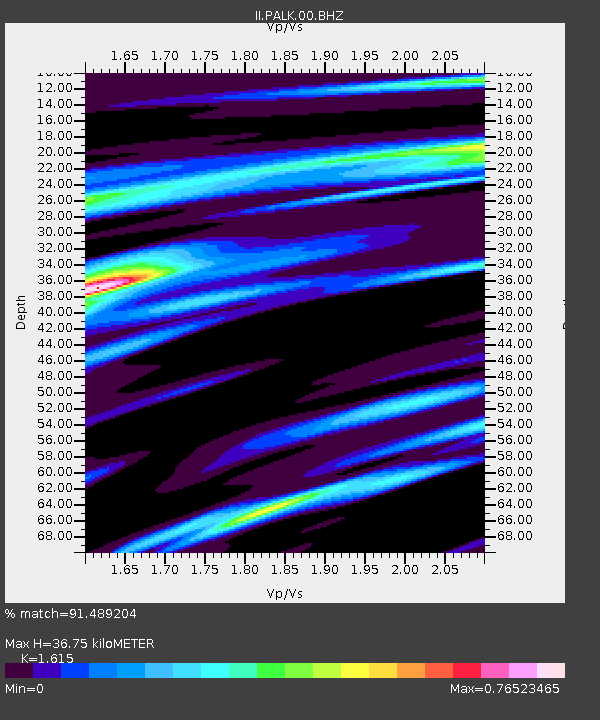
| Estimated Moho Depth: |
36.75 km |
| Estimated Crust Vp/Vs: |
1.62 |
| Assumed Crust Vp: |
6.545 km/s |
| Estimated Crust Vs: |
4.053 km/s |
| Estimated Crust Poisson's Ratio: |
0.19 |
|
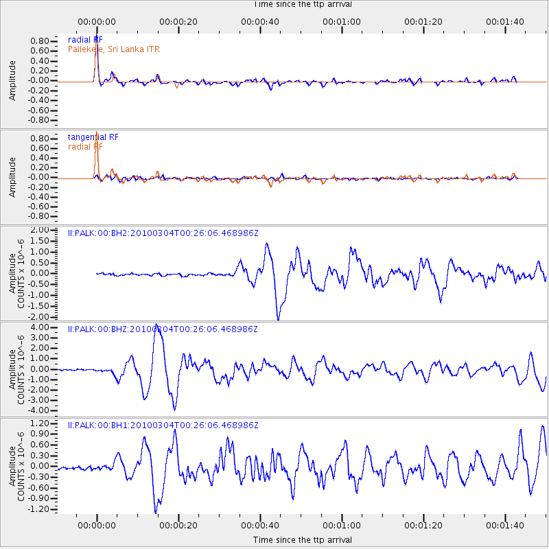
| Radial Match: |
91.489204 % |
| Radial Bump: |
400 |
| Transverse Match: |
70.93452 % |
| Transverse Bump: |
400 |
| SOD ConfigId: |
617450 |
| Insert Time: |
2013-10-01 01:20:41.271 +0000 |
| GWidth: |
2.5 |
| Max Bumps: |
400 |
| Tol: |
0.001 |
|
Signal To Noise
| Channel | StoN | STA | LTA |
| II:PALK:00:BHZ:20100304T00:26:06.468986Z | 4.811495 | 2.8857184E-7 | 5.9975505E-8 |
| II:PALK:00:BH1:20100304T00:26:06.468986Z | 2.3941855 | 1.09080595E-7 | 4.5560633E-8 |
| II:PALK:00:BH2:20100304T00:26:06.468986Z | 3.2097597 | 1.4500709E-7 | 4.5176932E-8 |
| Arrivals |
| Ps | 3.7 SECOND |
| PpPs | 14 SECOND |
| PsPs/PpSs | 17 SECOND |


