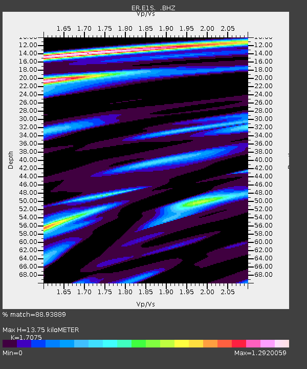
E1S PLACE HOLDER, Mt. Erebus Volcano Seismic Network - Earthquake Result Viewer

Earthquake location: Near Coast Of Central Chile
Earthquake latitude/longitude: -36.7/-73.4
Earthquake time(UTC): 2010/03/05 (064) 11:47:06 GMT
Earthquake Depth: 18 km
Earthquake Magnitude: 6.1 MB, 6.7 MS, 6.6 MW, 6.6 MW
Earthquake Catalog/Contributor: WHDF/NEIC
Network: ER Mount Erebus Volcano Observatory Seismic Network
Station: E1S PLACE HOLDER, Mt. Erebus Volcano Seismic Network
Lat/Lon: 77.53 S/167.14 E
Elevation: 3712 m
Distance: 60.4 deg
Az: 192.569 deg
Baz: 126.374 deg
Ray Param: 0.061556656
Estimated Moho Depth: 13.75 km
Estimated Crust Vp/Vs: 1.71
Assumed Crust Vp: 6.183 km/s
Estimated Crust Vs: 3.621 km/s
Estimated Crust Poisson's Ratio: 0.24
Radial Match: 88.93889 %
Radial Bump: 390
Transverse Match: 73.299324 %
Transverse Bump: 400
SOD ConfigId: 617450
Insert Time: 2013-10-01 01:33:05.862 +0000
GWidth: 2.5
Max Bumps: 400
Tol: 0.001

Signal To Noise

ChannelStoNSTALTA
ER:E1S: :BHZ:20100305T11:56:43.725029Z1.71262267.384525E-74.3118226E-7
ER:E1S: :BH1:20100305T11:56:43.725029Z1.22289845.112373E-74.1805382E-7
ER:E1S: :BH2:20100305T11:56:43.725029Z1.33537026.177405E-74.625987E-7
Arrivals
Ps1.6 SECOND
PpPs5.8 SECOND
PsPs/PpSs7.4 SECOND