You are here: Home > Network List > IU - Global Seismograph Network (GSN - IRIS/USGS) Stations List
> Station RSSD Black Hills, South Dakota, USA > Earthquake Result Viewer
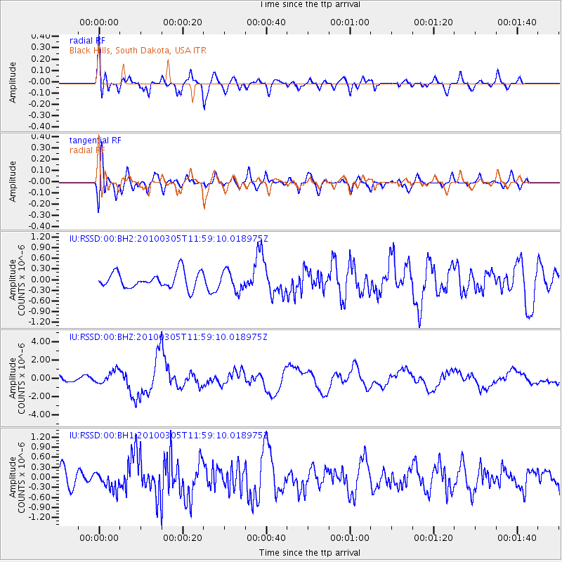
RSSD Black Hills, South Dakota, USA - Earthquake Result Viewer
*The percent match for this event was below the threshold and hence no stack was calculated.
| Earthquake location: |
Near Coast Of Central Chile |
| Earthquake latitude/longitude: |
-36.7/-73.4 |
| Earthquake time(UTC): |
2010/03/05 (064) 11:47:06 GMT |
| Earthquake Depth: |
18 km |
| Earthquake Magnitude: |
6.1 MB, 6.7 MS, 6.6 MW, 6.6 MW |
| Earthquake Catalog/Contributor: |
WHDF/NEIC |
|
| Network: |
IU Global Seismograph Network (GSN - IRIS/USGS) |
| Station: |
RSSD Black Hills, South Dakota, USA |
| Lat/Lon: |
44.12 N/104.04 W |
| Elevation: |
2090 m |
|
| Distance: |
85.1 deg |
| Az: |
338.368 deg |
| Baz: |
155.697 deg |
| Ray Param: |
$rayparam |
*The percent match for this event was below the threshold and hence was not used in the summary stack. |
|
| Radial Match: |
71.827286 % |
| Radial Bump: |
400 |
| Transverse Match: |
64.87869 % |
| Transverse Bump: |
400 |
| SOD ConfigId: |
617450 |
| Insert Time: |
2013-10-01 01:33:26.522 +0000 |
| GWidth: |
2.5 |
| Max Bumps: |
400 |
| Tol: |
0.001 |
|
Signal To Noise
| Channel | StoN | STA | LTA |
| IU:RSSD:00:BHZ:20100305T11:59:10.018975Z | 2.7462387 | 7.299125E-7 | 2.6578624E-7 |
| IU:RSSD:00:BH1:20100305T11:59:10.018975Z | 0.628981 | 2.553628E-7 | 4.0599448E-7 |
| IU:RSSD:00:BH2:20100305T11:59:10.018975Z | 1.2556186 | 2.8126004E-7 | 2.240012E-7 |
| Arrivals |
| Ps | |
| PpPs | |
| PsPs/PpSs | |


