You are here: Home > Network List > II - Global Seismograph Network (GSN - IRIS/IDA) Stations List
> Station KAPI Kappang, Sulawesi, Indonesia > Earthquake Result Viewer
KAPI Kappang, Sulawesi, Indonesia - Earthquake Result Viewer
| Earthquake location: |
Turkey |
| Earthquake latitude/longitude: |
38.9/40.0 |
| Earthquake time(UTC): |
2010/03/08 (067) 02:32:34 GMT |
| Earthquake Depth: |
12 km |
| Earthquake Magnitude: |
5.9 MB, 6.0 MS, 6.1 MW, 6.1 MW |
| Earthquake Catalog/Contributor: |
WHDF/NEIC |
|
| Network: |
II Global Seismograph Network (GSN - IRIS/IDA) |
| Station: |
KAPI Kappang, Sulawesi, Indonesia |
| Lat/Lon: |
5.01 S/119.75 E |
| Elevation: |
300 m |
|
| Distance: |
85.2 deg |
| Az: |
100.314 deg |
| Baz: |
309.56 deg |
| Ray Param: |
0.044942334 |
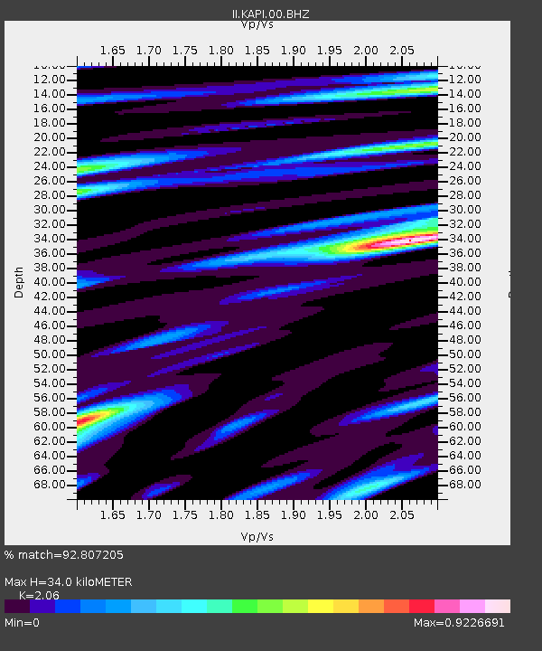
| Estimated Moho Depth: |
34.0 km |
| Estimated Crust Vp/Vs: |
2.06 |
| Assumed Crust Vp: |
6.343 km/s |
| Estimated Crust Vs: |
3.079 km/s |
| Estimated Crust Poisson's Ratio: |
0.35 |
|
| Radial Match: |
92.807205 % |
| Radial Bump: |
350 |
| Transverse Match: |
77.73804 % |
| Transverse Bump: |
400 |
| SOD ConfigId: |
617450 |
| Insert Time: |
2013-10-01 01:48:04.030 +0000 |
| GWidth: |
2.5 |
| Max Bumps: |
400 |
| Tol: |
0.001 |
|

Signal To Noise
| Channel | StoN | STA | LTA |
| II:KAPI:00:BHZ:20100308T02:44:39.318989Z | 15.417212 | 1.0123096E-6 | 6.5661E-8 |
| II:KAPI:00:BH1:20100308T02:44:39.318989Z | 3.6055002 | 1.8915001E-7 | 5.246152E-8 |
| II:KAPI:00:BH2:20100308T02:44:39.318989Z | 4.9735556 | 2.8077415E-7 | 5.6453406E-8 |
| Arrivals |
| Ps | 5.8 SECOND |
| PpPs | 16 SECOND |
| PsPs/PpSs | 22 SECOND |


