You are here: Home > Network List > IU - Global Seismograph Network (GSN - IRIS/USGS) Stations List
> Station TEIG Tepich, Yucatan, Mexico > Earthquake Result Viewer
TEIG Tepich, Yucatan, Mexico - Earthquake Result Viewer

| Earthquake location: |
Near Coast Of Central Chile |
| Earthquake latitude/longitude: |
-34.3/-71.9 |
| Earthquake time(UTC): |
2010/03/11 (070) 14:39:43 GMT |
| Earthquake Depth: |
11 km |
| Earthquake Magnitude: |
6.7 MB, 7.0 MS, 6.9 MW, 6.9 MW |
| Earthquake Catalog/Contributor: |
WHDF/NEIC |
|
| Network: |
IU Global Seismograph Network (GSN - IRIS/USGS) |
| Station: |
TEIG Tepich, Yucatan, Mexico |
| Lat/Lon: |
20.23 N/88.28 W |
| Elevation: |
40 m |
|
| Distance: |
56.4 deg |
| Az: |
341.458 deg |
| Baz: |
163.718 deg |
| Ray Param: |
0.064155705 |
| Estimated Moho Depth: |
49.5 km |
| Estimated Crust Vp/Vs: |
1.98 |
| Assumed Crust Vp: |
5.817 km/s |
| Estimated Crust Vs: |
2.942 km/s |
| Estimated Crust Poisson's Ratio: |
0.33 |
|
| Radial Match: |
95.49494 % |
| Radial Bump: |
356 |
| Transverse Match: |
95.60576 % |
| Transverse Bump: |
333 |
| SOD ConfigId: |
617450 |
| Insert Time: |
2013-10-01 02:00:56.978 +0000 |
| GWidth: |
2.5 |
| Max Bumps: |
400 |
| Tol: |
0.001 |
|
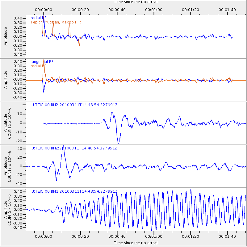
Signal To Noise
| Channel | StoN | STA | LTA |
| IU:TEIG:00:BHZ:20100311T14:48:54.327991Z | 16.461857 | 4.975714E-6 | 3.0225715E-7 |
| IU:TEIG:00:BH1:20100311T14:48:54.327991Z | 1.1755803 | 3.2653414E-8 | 2.7776421E-8 |
| IU:TEIG:00:BH2:20100311T14:48:54.327991Z | 8.126585 | 2.2436395E-6 | 2.7608638E-7 |
| Arrivals |
| Ps | 8.6 SECOND |
| PpPs | 24 SECOND |
| PsPs/PpSs | 33 SECOND |


