You are here: Home > Network List > XL12 - Hangay Dome, Mongolia Stations List
> Station AT14 AT14 > Earthquake Result Viewer
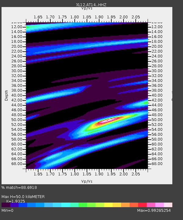
AT14 AT14 - Earthquake Result Viewer
| Earthquake location: |
Ryukyu Islands, Japan |
| Earthquake latitude/longitude: |
27.5/128.4 |
| Earthquake time(UTC): |
2014/10/22 (295) 00:15:17 GMT |
| Earthquake Depth: |
42 km |
| Earthquake Magnitude: |
5.8 MB |
| Earthquake Catalog/Contributor: |
NEIC PDE/NEIC COMCAT |
|
| Network: |
XL Hangay Dome, Mongolia |
| Station: |
AT14 AT14 |
| Lat/Lon: |
45.36 N/96.64 E |
| Elevation: |
2289 m |
|
| Distance: |
30.9 deg |
| Az: |
313.658 deg |
| Baz: |
114.309 deg |
| Ray Param: |
0.07916543 |
| Estimated Moho Depth: |
50.0 km |
| Estimated Crust Vp/Vs: |
1.93 |
| Assumed Crust Vp: |
6.353 km/s |
| Estimated Crust Vs: |
3.287 km/s |
| Estimated Crust Poisson's Ratio: |
0.32 |
|
| Radial Match: |
88.6918 % |
| Radial Bump: |
400 |
| Transverse Match: |
41.27821 % |
| Transverse Bump: |
400 |
| SOD ConfigId: |
3390531 |
| Insert Time: |
2019-04-14 16:19:34.909 +0000 |
| GWidth: |
2.5 |
| Max Bumps: |
400 |
| Tol: |
0.001 |
|

Signal To Noise
| Channel | StoN | STA | LTA |
| XL:AT14: :HHZ:20141022T00:21:00.449014Z | 4.716628 | 2.800409E-7 | 5.9373114E-8 |
| XL:AT14: :HHN:20141022T00:21:00.449014Z | 3.2181904 | 2.4124571E-7 | 7.496316E-8 |
| XL:AT14: :HHE:20141022T00:21:00.449014Z | 1.6890157 | 1.3766868E-7 | 8.150823E-8 |
| Arrivals |
| Ps | 7.9 SECOND |
| PpPs | 21 SECOND |
| PsPs/PpSs | 29 SECOND |


