You are here: Home > Network List > II - Global Seismograph Network (GSN - IRIS/IDA) Stations List
> Station KURK Kurchatov, Kazakhstan > Earthquake Result Viewer
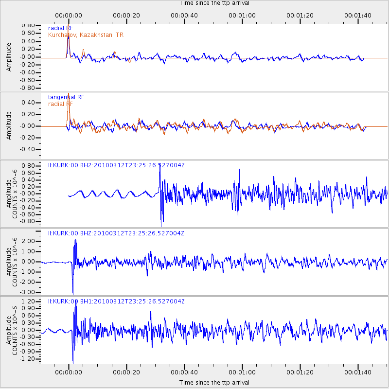
KURK Kurchatov, Kazakhstan - Earthquake Result Viewer
*The percent match for this event was below the threshold and hence no stack was calculated.
| Earthquake location: |
Myanmar-India Border Region |
| Earthquake latitude/longitude: |
23.1/94.6 |
| Earthquake time(UTC): |
2010/03/12 (071) 23:19:55 GMT |
| Earthquake Depth: |
102 km |
| Earthquake Magnitude: |
5.5 MB, 5.5 MW |
| Earthquake Catalog/Contributor: |
WHDF/NEIC |
|
| Network: |
II Global Seismograph Network (GSN - IRIS/IDA) |
| Station: |
KURK Kurchatov, Kazakhstan |
| Lat/Lon: |
50.72 N/78.62 E |
| Elevation: |
184 m |
|
| Distance: |
30.3 deg |
| Az: |
339.667 deg |
| Baz: |
149.773 deg |
| Ray Param: |
$rayparam |
*The percent match for this event was below the threshold and hence was not used in the summary stack. |
|
| Radial Match: |
69.42681 % |
| Radial Bump: |
400 |
| Transverse Match: |
62.591324 % |
| Transverse Bump: |
400 |
| SOD ConfigId: |
617450 |
| Insert Time: |
2013-10-01 02:14:13.600 +0000 |
| GWidth: |
2.5 |
| Max Bumps: |
400 |
| Tol: |
0.001 |
|
Signal To Noise
| Channel | StoN | STA | LTA |
| II:KURK:00:BHZ:20100312T23:25:26.527004Z | 16.610939 | 9.0339023E-7 | 5.4385257E-8 |
| II:KURK:00:BH1:20100312T23:25:26.527004Z | 7.412851 | 4.5984785E-7 | 6.203387E-8 |
| II:KURK:00:BH2:20100312T23:25:26.527004Z | 5.335238 | 3.3727392E-7 | 6.321628E-8 |
| Arrivals |
| Ps | |
| PpPs | |
| PsPs/PpSs | |


