You are here: Home > Network List > II - Global Seismograph Network (GSN - IRIS/IDA) Stations List
> Station PALK Pallekele, Sri Lanka > Earthquake Result Viewer
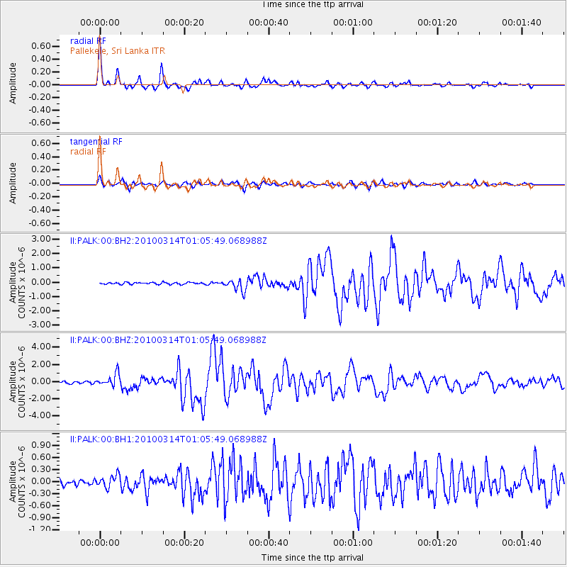
PALK Pallekele, Sri Lanka - Earthquake Result Viewer

| Earthquake location: |
Halmahera, Indonesia |
| Earthquake latitude/longitude: |
-1.7/128.1 |
| Earthquake time(UTC): |
2010/03/14 (073) 00:57:44 GMT |
| Earthquake Depth: |
53 km |
| Earthquake Magnitude: |
6.3 MB, 6.4 MW, 6.4 MW |
| Earthquake Catalog/Contributor: |
WHDF/NEIC |
|
| Network: |
II Global Seismograph Network (GSN - IRIS/IDA) |
| Station: |
PALK Pallekele, Sri Lanka |
| Lat/Lon: |
7.27 N/80.70 E |
| Elevation: |
460 m |
|
| Distance: |
48.2 deg |
| Az: |
281.254 deg |
| Baz: |
98.813 deg |
| Ray Param: |
0.06940274 |
| Estimated Moho Depth: |
38.5 km |
| Estimated Crust Vp/Vs: |
1.67 |
| Assumed Crust Vp: |
6.545 km/s |
| Estimated Crust Vs: |
3.919 km/s |
| Estimated Crust Poisson's Ratio: |
0.22 |
|
| Radial Match: |
95.68379 % |
| Radial Bump: |
289 |
| Transverse Match: |
87.34311 % |
| Transverse Bump: |
400 |
| SOD ConfigId: |
617450 |
| Insert Time: |
2013-10-01 02:23:12.999 +0000 |
| GWidth: |
2.5 |
| Max Bumps: |
400 |
| Tol: |
0.001 |
|
Signal To Noise
| Channel | StoN | STA | LTA |
| II:PALK:00:BHZ:20100314T01:05:49.068988Z | 5.9932976 | 7.4469915E-7 | 1.2425532E-7 |
| II:PALK:00:BH1:20100314T01:05:49.068988Z | 1.7147424 | 1.5495536E-7 | 9.036655E-8 |
| II:PALK:00:BH2:20100314T01:05:49.068988Z | 6.471335 | 4.1410587E-7 | 6.39908E-8 |
| Arrivals |
| Ps | 4.2 SECOND |
| PpPs | 15 SECOND |
| PsPs/PpSs | 19 SECOND |


