MSEY Mahe, Seychelles - Earthquake Result Viewer
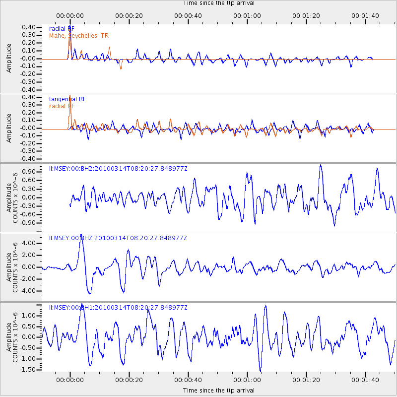
Earthquake location: Near East Coast Of Honshu, Japan
Earthquake latitude/longitude: 37.7/141.6
Earthquake time(UTC): 2010/03/14 (073) 08:08:03 GMT
Earthquake Depth: 32 km
Earthquake Magnitude: 6.5 MW, 6.3 MB, 6.4 MS, 6.5 MW
Earthquake Catalog/Contributor: NEIC PDE/NEIC PDE-M
Network: II Global Seismograph Network (GSN - IRIS/IDA)
Station: MSEY Mahe, Seychelles
Lat/Lon: 4.67 S/55.48 E
Elevation: 475 m
Distance: 89.8 deg
Az: 263.951 deg
Baz: 52.271 deg
Ray Param: 0.0417182
Estimated Moho Depth: 13.0 km
Estimated Crust Vp/Vs: 1.87
Assumed Crust Vp: 6.303 km/s
Estimated Crust Vs: 3.37 km/s
Estimated Crust Poisson's Ratio: 0.30
Radial Match: 83.542595 %
Radial Bump: 341
Transverse Match: 82.733986 %
Transverse Bump: 400
SOD ConfigId: 617450
Insert Time: 2013-10-01 02:27:00.877 +0000
GWidth: 2.5
Max Bumps: 400
Tol: 0.001

Signal To Noise

ChannelStoNSTALTA
II:MSEY:00:BHZ:20100314T08:20:27.848977Z7.4589272.5364425E-63.400546E-7
II:MSEY:00:BH1:20100314T08:20:27.848977Z3.94389187.658991E-71.9419882E-7
II:MSEY:00:BH2:20100314T08:20:27.848977Z1.38140992.4832732E-71.7976369E-7
Arrivals
Ps1.8 SECOND
PpPs5.8 SECOND
PsPs/PpSs7.6 SECOND