You are here: Home > Network List > II - Global Seismograph Network (GSN - IRIS/IDA) Stations List
> Station KAPI Kappang, Sulawesi, Indonesia > Earthquake Result Viewer
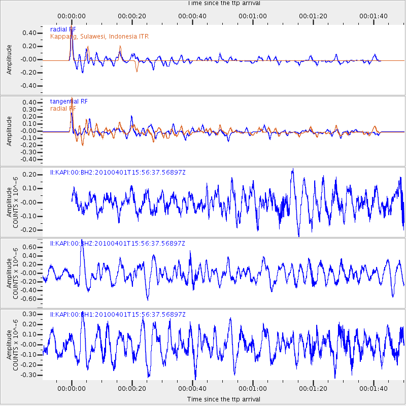
KAPI Kappang, Sulawesi, Indonesia - Earthquake Result Viewer
*The percent match for this event was below the threshold and hence no stack was calculated.
| Earthquake location: |
Balleny Islands Region |
| Earthquake latitude/longitude: |
-61.2/153.9 |
| Earthquake time(UTC): |
2010/04/01 (091) 15:46:51 GMT |
| Earthquake Depth: |
10 km |
| Earthquake Magnitude: |
5.6 MW, 5.6 MW |
| Earthquake Catalog/Contributor: |
NEIC PDE/NEIC PDE-M |
|
| Network: |
II Global Seismograph Network (GSN - IRIS/IDA) |
| Station: |
KAPI Kappang, Sulawesi, Indonesia |
| Lat/Lon: |
5.01 S/119.75 E |
| Elevation: |
300 m |
|
| Distance: |
61.6 deg |
| Az: |
320.566 deg |
| Baz: |
162.018 deg |
| Ray Param: |
$rayparam |
*The percent match for this event was below the threshold and hence was not used in the summary stack. |
|
| Radial Match: |
81.27473 % |
| Radial Bump: |
400 |
| Transverse Match: |
73.57198 % |
| Transverse Bump: |
400 |
| SOD ConfigId: |
617450 |
| Insert Time: |
2013-10-01 03:17:10.467 +0000 |
| GWidth: |
2.5 |
| Max Bumps: |
400 |
| Tol: |
0.001 |
|
Signal To Noise
| Channel | StoN | STA | LTA |
| II:KAPI:00:BHZ:20100401T15:56:37.56897Z | 4.740577 | 3.1574743E-7 | 6.660527E-8 |
| II:KAPI:00:BH1:20100401T15:56:37.56897Z | 2.5390778 | 1.4762414E-7 | 5.814085E-8 |
| II:KAPI:00:BH2:20100401T15:56:37.56897Z | 0.85378325 | 4.586992E-8 | 5.3725486E-8 |
| Arrivals |
| Ps | |
| PpPs | |
| PsPs/PpSs | |


