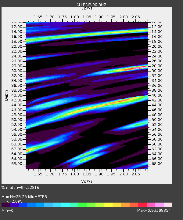
BCIP Isla Barro Colorado, Panama - Earthquake Result Viewer

Earthquake location: Calif.-Baja Calif. Border Region
Earthquake latitude/longitude: 32.3/-115.3
Earthquake time(UTC): 2010/04/04 (094) 22:40:43 GMT
Earthquake Depth: 4.0 km
Earthquake Magnitude: 7.2 MW, 6.4 MB, 7.2 MW, 7.3 MS
Earthquake Catalog/Contributor: NEIC PDE/NEIC PDE-M
Network: CU Caribbean Network (USGS)
Station: BCIP Isla Barro Colorado, Panama
Lat/Lon: 9.17 N/79.84 W
Elevation: 61 m
Distance: 40.1 deg
Az: 117.158 deg
Baz: 310.257 deg
Ray Param: 0.07463347
Estimated Moho Depth: 28.25 km
Estimated Crust Vp/Vs: 2.10
Assumed Crust Vp: 6.436 km/s
Estimated Crust Vs: 3.072 km/s
Estimated Crust Poisson's Ratio: 0.35
Radial Match: 94.12816 %
Radial Bump: 400
Transverse Match: 88.00494 %
Transverse Bump: 400
SOD ConfigId: 617450
Insert Time: 2013-10-01 03:22:15.142 +0000
GWidth: 2.5
Max Bumps: 400
Tol: 0.001

Signal To Noise

ChannelStoNSTALTA
CU:BCIP:00:BHZ:20100404T22:47:48.450006Z1.9722964.4154336E-72.2387277E-7
CU:BCIP:00:BH1:20100404T22:47:48.450006Z2.061146.591198E-73.197841E-7
CU:BCIP:00:BH2:20100404T22:47:48.450006Z0.96414191.9263479E-71.997992E-7
Arrivals
Ps5.1 SECOND
PpPs13 SECOND
PsPs/PpSs18 SECOND