You are here: Home > Network List > CI - Caltech Regional Seismic Network Stations List
> Station TIN Tinemaha, California, USA > Earthquake Result Viewer
TIN Tinemaha, California, USA - Earthquake Result Viewer
| Earthquake location: |
Unimak Island Region, Alaska |
| Earthquake latitude/longitude: |
53.6/-164.6 |
| Earthquake time(UTC): |
2003/02/19 (050) 03:32:36 GMT |
| Earthquake Depth: |
19 km |
| Earthquake Magnitude: |
5.8 MB, 6.6 MS, 6.6 MW, 6.6 MW |
| Earthquake Catalog/Contributor: |
WHDF/NEIC |
|
| Network: |
CI Caltech Regional Seismic Network |
| Station: |
TIN Tinemaha, California, USA |
| Lat/Lon: |
37.05 N/118.23 W |
| Elevation: |
1164 m |
|
| Distance: |
35.9 deg |
| Az: |
98.436 deg |
| Baz: |
312.595 deg |
| Ray Param: |
0.07697345 |
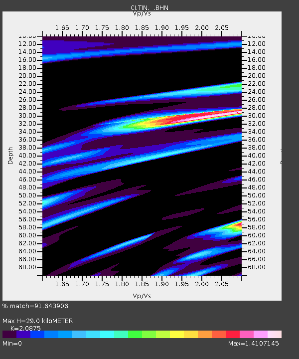
| Estimated Moho Depth: |
29.0 km |
| Estimated Crust Vp/Vs: |
2.09 |
| Assumed Crust Vp: |
6.291 km/s |
| Estimated Crust Vs: |
3.014 km/s |
| Estimated Crust Poisson's Ratio: |
0.35 |
|
| Radial Match: |
91.643906 % |
| Radial Bump: |
400 |
| Transverse Match: |
79.08572 % |
| Transverse Bump: |
400 |
| SOD ConfigId: |
3770 |
| Insert Time: |
2010-02-25 20:47:47.519 +0000 |
| GWidth: |
2.5 |
| Max Bumps: |
400 |
| Tol: |
0.001 |
|
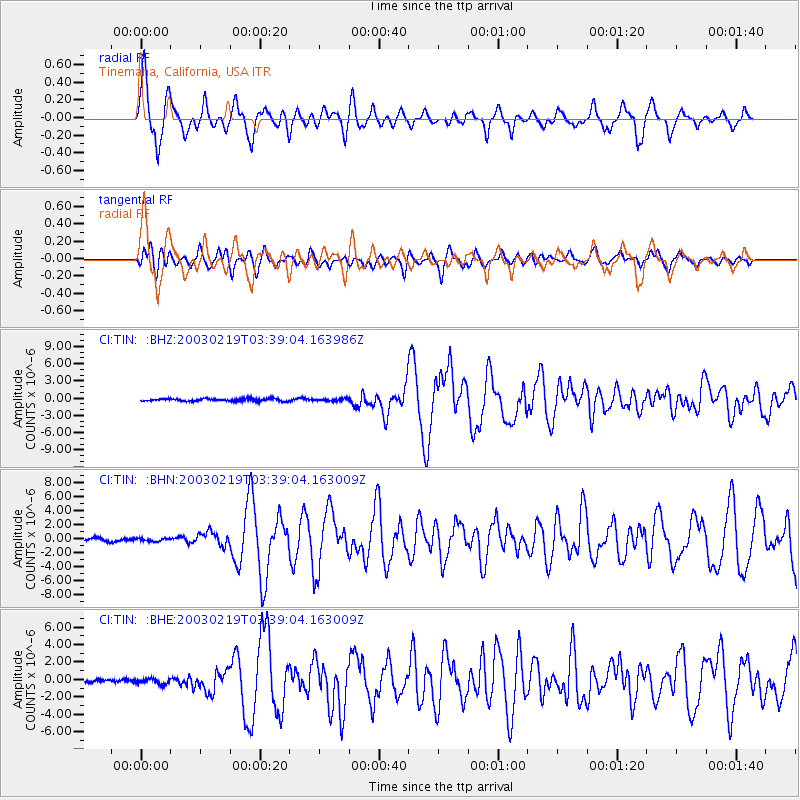
Signal To Noise
| Channel | StoN | STA | LTA |
| CI:TIN: :BHN:20030219T03:39:04.163009Z | 0.8526189 | 2.0105107E-7 | 2.3580415E-7 |
| CI:TIN: :BHE:20030219T03:39:04.163009Z | 1.3211036 | 3.3179094E-7 | 2.5114682E-7 |
| CI:TIN: :BHZ:20030219T03:39:04.163986Z | 0.88975936 | 1.9491341E-7 | 2.1906305E-7 |
| Arrivals |
| Ps | 5.3 SECOND |
| PpPs | 13 SECOND |
| PsPs/PpSs | 19 SECOND |


