You are here: Home > Network List > IU - Global Seismograph Network (GSN - IRIS/USGS) Stations List
> Station TEIG Tepich, Yucatan, Mexico > Earthquake Result Viewer
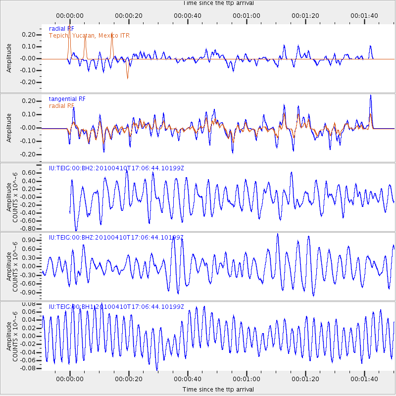
TEIG Tepich, Yucatan, Mexico - Earthquake Result Viewer
*The percent match for this event was below the threshold and hence no stack was calculated.
| Earthquake location: |
Fiji Islands Region |
| Earthquake latitude/longitude: |
-20.1/-176.2 |
| Earthquake time(UTC): |
2010/04/10 (100) 16:54:24 GMT |
| Earthquake Depth: |
273 km |
| Earthquake Magnitude: |
5.9 MW, 5.5 MB, 6.0 MW |
| Earthquake Catalog/Contributor: |
NEIC PDE/NEIC PDE-M |
|
| Network: |
IU Global Seismograph Network (GSN - IRIS/USGS) |
| Station: |
TEIG Tepich, Yucatan, Mexico |
| Lat/Lon: |
20.23 N/88.28 W |
| Elevation: |
40 m |
|
| Distance: |
94.9 deg |
| Az: |
70.383 deg |
| Baz: |
250.498 deg |
| Ray Param: |
$rayparam |
*The percent match for this event was below the threshold and hence was not used in the summary stack. |
|
| Radial Match: |
49.033875 % |
| Radial Bump: |
400 |
| Transverse Match: |
48.75298 % |
| Transverse Bump: |
400 |
| SOD ConfigId: |
617450 |
| Insert Time: |
2013-10-01 03:41:10.516 +0000 |
| GWidth: |
2.5 |
| Max Bumps: |
400 |
| Tol: |
0.001 |
|
Signal To Noise
| Channel | StoN | STA | LTA |
| IU:TEIG:00:BHZ:20100410T17:06:44.10199Z | 1.8222313 | 4.407698E-7 | 2.4188466E-7 |
| IU:TEIG:00:BH1:20100410T17:06:44.10199Z | 1.2670159 | 5.0284743E-8 | 3.968754E-8 |
| IU:TEIG:00:BH2:20100410T17:06:44.10199Z | 0.8410693 | 2.7303156E-7 | 3.2462432E-7 |
| Arrivals |
| Ps | |
| PpPs | |
| PsPs/PpSs | |


