You are here: Home > Network List > II - Global Seismograph Network (GSN - IRIS/IDA) Stations List
> Station PALK Pallekele, Sri Lanka > Earthquake Result Viewer
PALK Pallekele, Sri Lanka - Earthquake Result Viewer
| Earthquake location: |
Solomon Islands |
| Earthquake latitude/longitude: |
-10.9/161.1 |
| Earthquake time(UTC): |
2010/04/11 (101) 09:40:25 GMT |
| Earthquake Depth: |
21 km |
| Earthquake Magnitude: |
6.9 MW, 6.6 MB, 6.8 MW, 7.0 MS |
| Earthquake Catalog/Contributor: |
NEIC PDE/NEIC PDE-M |
|
| Network: |
II Global Seismograph Network (GSN - IRIS/IDA) |
| Station: |
PALK Pallekele, Sri Lanka |
| Lat/Lon: |
7.27 N/80.70 E |
| Elevation: |
460 m |
|
| Distance: |
82.0 deg |
| Az: |
278.976 deg |
| Baz: |
102.04 deg |
| Ray Param: |
0.04715231 |
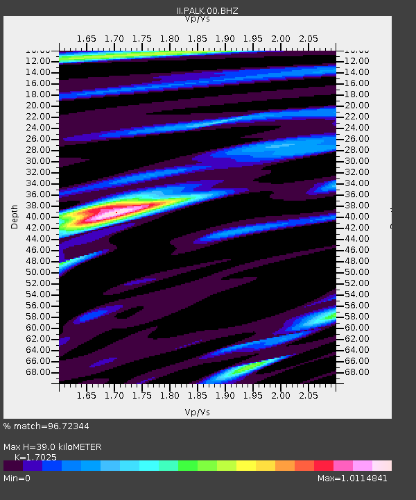
| Estimated Moho Depth: |
39.0 km |
| Estimated Crust Vp/Vs: |
1.70 |
| Assumed Crust Vp: |
6.545 km/s |
| Estimated Crust Vs: |
3.845 km/s |
| Estimated Crust Poisson's Ratio: |
0.24 |
|
| Radial Match: |
96.72344 % |
| Radial Bump: |
400 |
| Transverse Match: |
83.04578 % |
| Transverse Bump: |
400 |
| SOD ConfigId: |
617450 |
| Insert Time: |
2013-10-01 03:48:01.155 +0000 |
| GWidth: |
2.5 |
| Max Bumps: |
400 |
| Tol: |
0.001 |
|
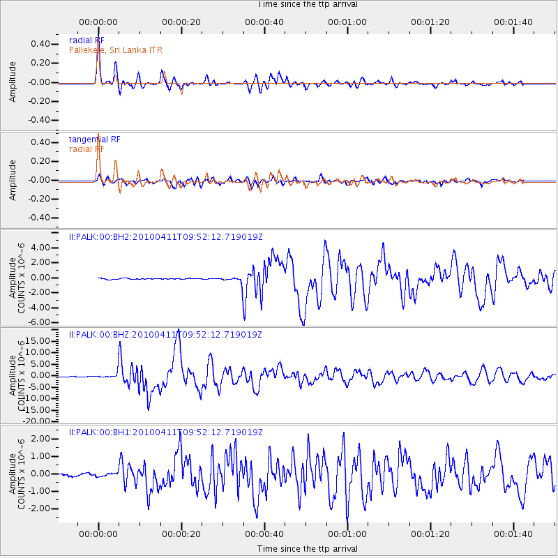
Signal To Noise
| Channel | StoN | STA | LTA |
| II:PALK:00:BHZ:20100411T09:52:12.719019Z | 14.614658 | 1.6080312E-6 | 1.1002865E-7 |
| II:PALK:00:BH1:20100411T09:52:12.719019Z | 1.3252494 | 9.9794555E-8 | 7.530247E-8 |
| II:PALK:00:BH2:20100411T09:52:12.719019Z | 9.079336 | 5.256691E-7 | 5.7897303E-8 |
| Arrivals |
| Ps | 4.3 SECOND |
| PpPs | 16 SECOND |
| PsPs/PpSs | 20 SECOND |


