You are here: Home > Network List > IU - Global Seismograph Network (GSN - IRIS/USGS) Stations List
> Station TATO Taipei, Taiwan > Earthquake Result Viewer
TATO Taipei, Taiwan - Earthquake Result Viewer
| Earthquake location: |
Solomon Islands |
| Earthquake latitude/longitude: |
-10.9/161.1 |
| Earthquake time(UTC): |
2010/04/11 (101) 09:40:25 GMT |
| Earthquake Depth: |
21 km |
| Earthquake Magnitude: |
6.9 MW, 6.6 MB, 6.8 MW, 7.0 MS |
| Earthquake Catalog/Contributor: |
NEIC PDE/NEIC PDE-M |
|
| Network: |
IU Global Seismograph Network (GSN - IRIS/USGS) |
| Station: |
TATO Taipei, Taiwan |
| Lat/Lon: |
24.97 N/121.50 E |
| Elevation: |
160 m |
|
| Distance: |
52.6 deg |
| Az: |
313.202 deg |
| Baz: |
127.914 deg |
| Ray Param: |
0.0666571 |
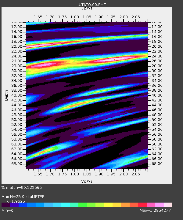
| Estimated Moho Depth: |
25.0 km |
| Estimated Crust Vp/Vs: |
1.96 |
| Assumed Crust Vp: |
6.289 km/s |
| Estimated Crust Vs: |
3.204 km/s |
| Estimated Crust Poisson's Ratio: |
0.32 |
|
| Radial Match: |
90.222565 % |
| Radial Bump: |
400 |
| Transverse Match: |
91.1466 % |
| Transverse Bump: |
400 |
| SOD ConfigId: |
617450 |
| Insert Time: |
2013-10-01 03:48:19.615 +0000 |
| GWidth: |
2.5 |
| Max Bumps: |
400 |
| Tol: |
0.001 |
|

Signal To Noise
| Channel | StoN | STA | LTA |
| IU:TATO:00:BHZ:20100411T09:49:06.568994Z | 11.813702 | 6.835295E-6 | 5.7859046E-7 |
| IU:TATO:00:BH1:20100411T09:49:06.568994Z | 4.725165 | 2.6429802E-6 | 5.5934134E-7 |
| IU:TATO:00:BH2:20100411T09:49:06.568994Z | 1.7779319 | 1.0267347E-6 | 5.7748815E-7 |
| Arrivals |
| Ps | 4.0 SECOND |
| PpPs | 11 SECOND |
| PsPs/PpSs | 15 SECOND |


