You are here: Home > Network List > CU - Caribbean Network (USGS) Stations List
> Station BBGH Gun Hill, Barbados > Earthquake Result Viewer
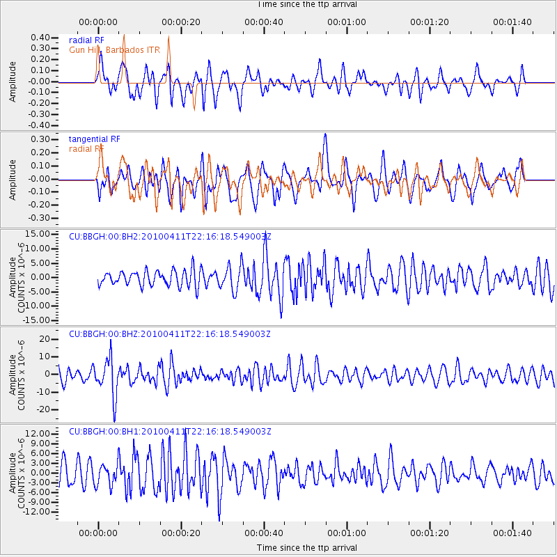
BBGH Gun Hill, Barbados - Earthquake Result Viewer
*The percent match for this event was below the threshold and hence no stack was calculated.
| Earthquake location: |
Strait Of Gibraltar |
| Earthquake latitude/longitude: |
37.0/-3.5 |
| Earthquake time(UTC): |
2010/04/11 (101) 22:08:12 GMT |
| Earthquake Depth: |
610 km |
| Earthquake Magnitude: |
6.3 MW, 6.0 MB, 6.3 MW |
| Earthquake Catalog/Contributor: |
NEIC PDE/NEIC PDE-M |
|
| Network: |
CU Caribbean Network (USGS) |
| Station: |
BBGH Gun Hill, Barbados |
| Lat/Lon: |
13.14 N/59.56 W |
| Elevation: |
180 m |
|
| Distance: |
55.2 deg |
| Az: |
259.82 deg |
| Baz: |
54.023 deg |
| Ray Param: |
$rayparam |
*The percent match for this event was below the threshold and hence was not used in the summary stack. |
|
| Radial Match: |
56.645092 % |
| Radial Bump: |
400 |
| Transverse Match: |
59.6013 % |
| Transverse Bump: |
400 |
| SOD ConfigId: |
617450 |
| Insert Time: |
2013-10-01 03:50:24.822 +0000 |
| GWidth: |
2.5 |
| Max Bumps: |
400 |
| Tol: |
0.001 |
|
Signal To Noise
| Channel | StoN | STA | LTA |
| CU:BBGH:00:BHZ:20100411T22:16:18.549003Z | 3.084219 | 1.0691459E-5 | 3.4665043E-6 |
| CU:BBGH:00:BH1:20100411T22:16:18.549003Z | 0.94918823 | 3.2356932E-6 | 3.4089055E-6 |
| CU:BBGH:00:BH2:20100411T22:16:18.549003Z | 1.6970671 | 4.4514272E-6 | 2.6230118E-6 |
| Arrivals |
| Ps | |
| PpPs | |
| PsPs/PpSs | |


