You are here: Home > Network List > II - Global Seismograph Network (GSN - IRIS/IDA) Stations List
> Station MSEY Mahe, Seychelles > Earthquake Result Viewer
MSEY Mahe, Seychelles - Earthquake Result Viewer
| Earthquake location: |
Strait Of Gibraltar |
| Earthquake latitude/longitude: |
37.0/-3.5 |
| Earthquake time(UTC): |
2010/04/11 (101) 22:08:12 GMT |
| Earthquake Depth: |
610 km |
| Earthquake Magnitude: |
6.3 MW, 6.0 MB, 6.3 MW |
| Earthquake Catalog/Contributor: |
NEIC PDE/NEIC PDE-M |
|
| Network: |
II Global Seismograph Network (GSN - IRIS/IDA) |
| Station: |
MSEY Mahe, Seychelles |
| Lat/Lon: |
4.67 S/55.48 E |
| Elevation: |
475 m |
|
| Distance: |
68.7 deg |
| Az: |
113.525 deg |
| Baz: |
312.542 deg |
| Ray Param: |
0.05391954 |
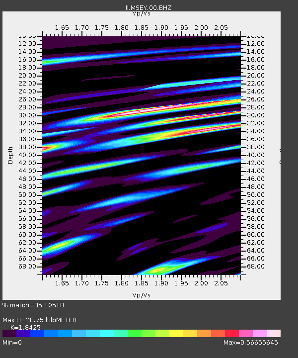
| Estimated Moho Depth: |
28.75 km |
| Estimated Crust Vp/Vs: |
1.84 |
| Assumed Crust Vp: |
6.303 km/s |
| Estimated Crust Vs: |
3.421 km/s |
| Estimated Crust Poisson's Ratio: |
0.29 |
|
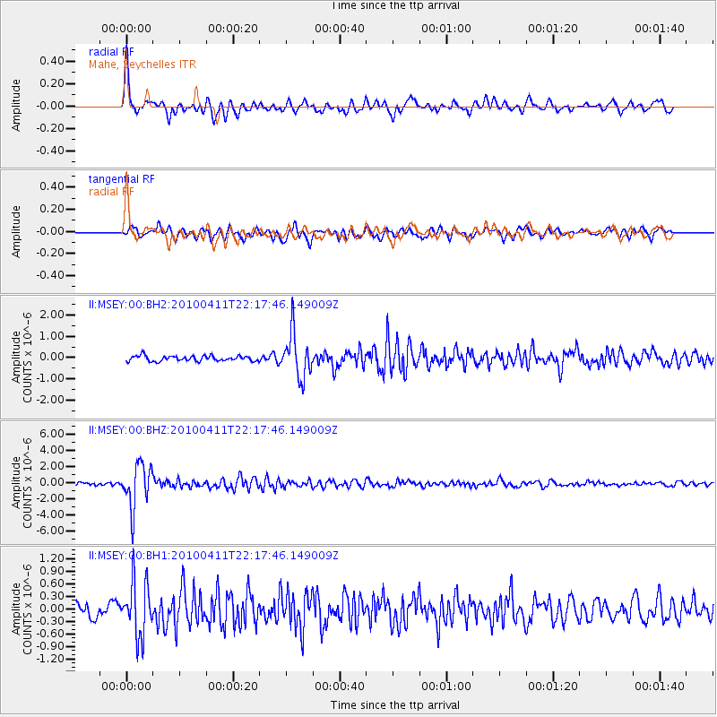
| Radial Match: |
85.10518 % |
| Radial Bump: |
400 |
| Transverse Match: |
77.11602 % |
| Transverse Bump: |
400 |
| SOD ConfigId: |
617450 |
| Insert Time: |
2013-10-01 03:50:55.137 +0000 |
| GWidth: |
2.5 |
| Max Bumps: |
400 |
| Tol: |
0.001 |
|
Signal To Noise
| Channel | StoN | STA | LTA |
| II:MSEY:00:BHZ:20100411T22:17:46.149009Z | 14.372082 | 2.691454E-6 | 1.8726959E-7 |
| II:MSEY:00:BH1:20100411T22:17:46.149009Z | 3.821903 | 6.5651443E-7 | 1.7177683E-7 |
| II:MSEY:00:BH2:20100411T22:17:46.149009Z | 8.424134 | 1.0404136E-6 | 1.2350392E-7 |
| Arrivals |
| Ps | 4.0 SECOND |
| PpPs | 13 SECOND |
| PsPs/PpSs | 17 SECOND |


