You are here: Home > Network List > II - Global Seismograph Network (GSN - IRIS/IDA) Stations List
> Station PALK Pallekele, Sri Lanka > Earthquake Result Viewer
PALK Pallekele, Sri Lanka - Earthquake Result Viewer
| Earthquake location: |
Strait Of Gibraltar |
| Earthquake latitude/longitude: |
37.0/-3.5 |
| Earthquake time(UTC): |
2010/04/11 (101) 22:08:12 GMT |
| Earthquake Depth: |
610 km |
| Earthquake Magnitude: |
6.3 MW, 6.0 MB, 6.3 MW |
| Earthquake Catalog/Contributor: |
NEIC PDE/NEIC PDE-M |
|
| Network: |
II Global Seismograph Network (GSN - IRIS/IDA) |
| Station: |
PALK Pallekele, Sri Lanka |
| Lat/Lon: |
7.27 N/80.70 E |
| Elevation: |
460 m |
|
| Distance: |
81.1 deg |
| Az: |
87.612 deg |
| Baz: |
306.23 deg |
| Ray Param: |
0.045954138 |
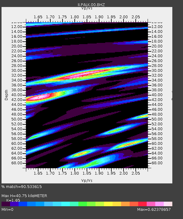
| Estimated Moho Depth: |
40.75 km |
| Estimated Crust Vp/Vs: |
1.65 |
| Assumed Crust Vp: |
6.545 km/s |
| Estimated Crust Vs: |
3.967 km/s |
| Estimated Crust Poisson's Ratio: |
0.21 |
|
| Radial Match: |
90.533615 % |
| Radial Bump: |
400 |
| Transverse Match: |
86.24486 % |
| Transverse Bump: |
400 |
| SOD ConfigId: |
617450 |
| Insert Time: |
2013-10-01 03:50:59.474 +0000 |
| GWidth: |
2.5 |
| Max Bumps: |
400 |
| Tol: |
0.001 |
|
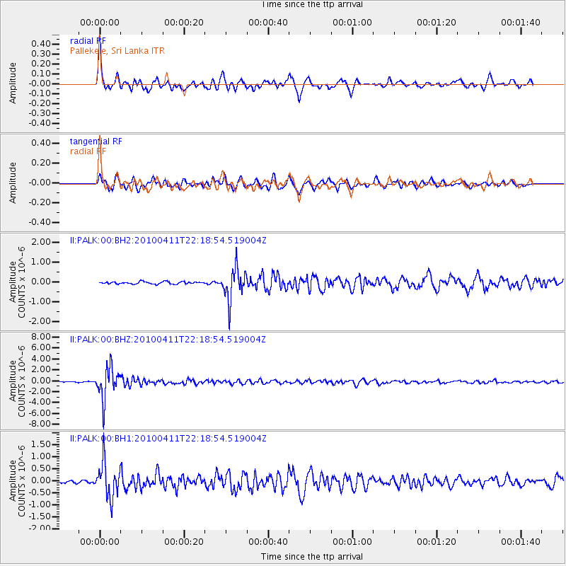
Signal To Noise
| Channel | StoN | STA | LTA |
| II:PALK:00:BHZ:20100411T22:18:54.519004Z | 39.31542 | 2.867967E-6 | 7.294764E-8 |
| II:PALK:00:BH1:20100411T22:18:54.519004Z | 12.576174 | 7.2057645E-7 | 5.7296955E-8 |
| II:PALK:00:BH2:20100411T22:18:54.519004Z | 13.791601 | 7.9090745E-7 | 5.7347034E-8 |
| Arrivals |
| Ps | 4.2 SECOND |
| PpPs | 16 SECOND |
| PsPs/PpSs | 20 SECOND |


