You are here: Home > Network List > IU - Global Seismograph Network (GSN - IRIS/USGS) Stations List
> Station TEIG Tepich, Yucatan, Mexico > Earthquake Result Viewer
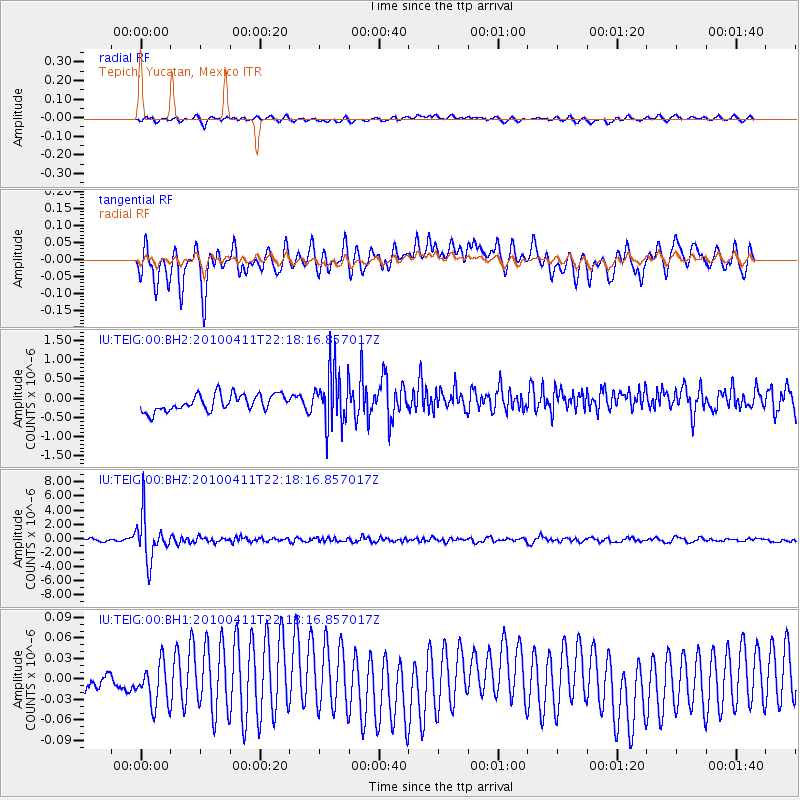
TEIG Tepich, Yucatan, Mexico - Earthquake Result Viewer
*The percent match for this event was below the threshold and hence no stack was calculated.
| Earthquake location: |
Strait Of Gibraltar |
| Earthquake latitude/longitude: |
37.0/-3.5 |
| Earthquake time(UTC): |
2010/04/11 (101) 22:08:12 GMT |
| Earthquake Depth: |
610 km |
| Earthquake Magnitude: |
6.3 MW, 6.0 MB, 6.3 MW |
| Earthquake Catalog/Contributor: |
NEIC PDE/NEIC PDE-M |
|
| Network: |
IU Global Seismograph Network (GSN - IRIS/USGS) |
| Station: |
TEIG Tepich, Yucatan, Mexico |
| Lat/Lon: |
20.23 N/88.28 W |
| Elevation: |
40 m |
|
| Distance: |
74.0 deg |
| Az: |
283.452 deg |
| Baz: |
56.047 deg |
| Ray Param: |
$rayparam |
*The percent match for this event was below the threshold and hence was not used in the summary stack. |
|
| Radial Match: |
75.79202 % |
| Radial Bump: |
400 |
| Transverse Match: |
63.08778 % |
| Transverse Bump: |
400 |
| SOD ConfigId: |
617450 |
| Insert Time: |
2013-10-01 03:51:33.209 +0000 |
| GWidth: |
2.5 |
| Max Bumps: |
400 |
| Tol: |
0.001 |
|
Signal To Noise
| Channel | StoN | STA | LTA |
| IU:TEIG:00:BHZ:20100411T22:18:16.857017Z | 18.038235 | 3.1279299E-6 | 1.7340555E-7 |
| IU:TEIG:00:BH1:20100411T22:18:16.857017Z | 1.1068858 | 3.2855038E-8 | 2.9682411E-8 |
| IU:TEIG:00:BH2:20100411T22:18:16.857017Z | 3.3517396 | 7.169636E-7 | 2.139079E-7 |
| Arrivals |
| Ps | |
| PpPs | |
| PsPs/PpSs | |


