You are here: Home > Network List > IU - Global Seismograph Network (GSN - IRIS/USGS) Stations List
> Station TEIG Tepich, Yucatan, Mexico > Earthquake Result Viewer
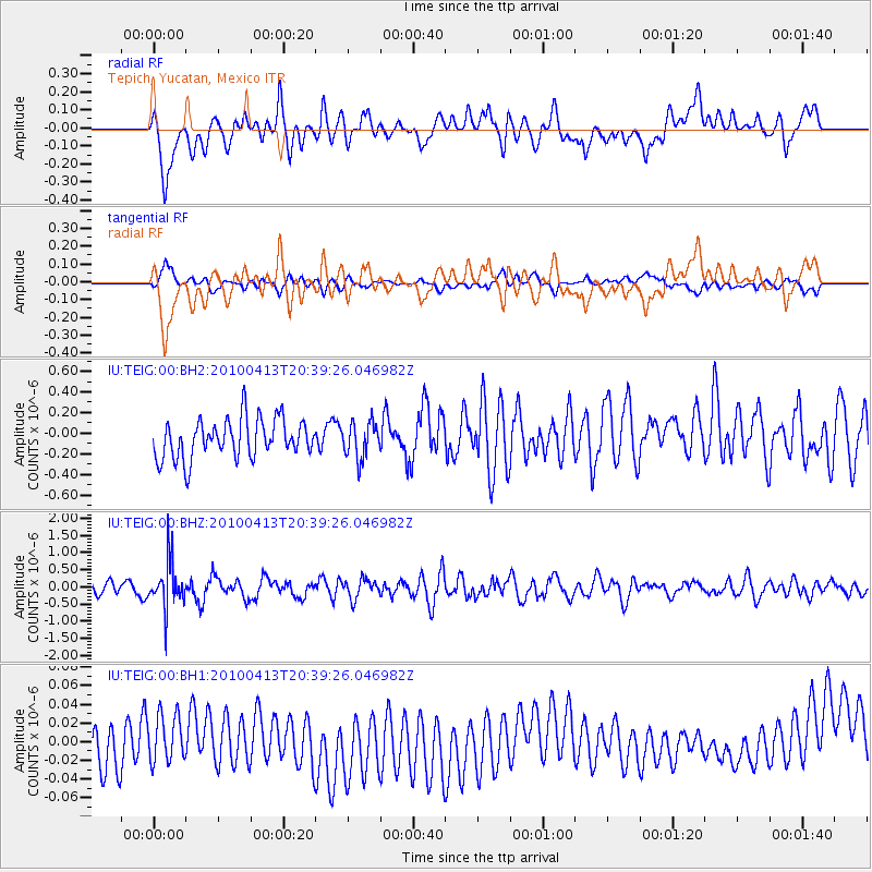
TEIG Tepich, Yucatan, Mexico - Earthquake Result Viewer
*The percent match for this event was below the threshold and hence no stack was calculated.
| Earthquake location: |
South Sandwich Islands Region |
| Earthquake latitude/longitude: |
-56.3/-27.3 |
| Earthquake time(UTC): |
2010/04/13 (103) 20:27:00 GMT |
| Earthquake Depth: |
100 km |
| Earthquake Magnitude: |
5.5 MW, 5.5 MW, 5.8 MB |
| Earthquake Catalog/Contributor: |
NEIC PDE/NEIC PDE-M |
|
| Network: |
IU Global Seismograph Network (GSN - IRIS/USGS) |
| Station: |
TEIG Tepich, Yucatan, Mexico |
| Lat/Lon: |
20.23 N/88.28 W |
| Elevation: |
40 m |
|
| Distance: |
91.8 deg |
| Az: |
304.767 deg |
| Baz: |
150.842 deg |
| Ray Param: |
$rayparam |
*The percent match for this event was below the threshold and hence was not used in the summary stack. |
|
| Radial Match: |
46.30706 % |
| Radial Bump: |
400 |
| Transverse Match: |
46.42554 % |
| Transverse Bump: |
400 |
| SOD ConfigId: |
617450 |
| Insert Time: |
2013-10-01 03:56:54.561 +0000 |
| GWidth: |
2.5 |
| Max Bumps: |
400 |
| Tol: |
0.001 |
|
Signal To Noise
| Channel | StoN | STA | LTA |
| IU:TEIG:00:BHZ:20100413T20:39:26.046982Z | 2.9287965 | 6.5414645E-7 | 2.233499E-7 |
| IU:TEIG:00:BH1:20100413T20:39:26.046982Z | 0.6639499 | 2.69833E-8 | 4.0640565E-8 |
| IU:TEIG:00:BH2:20100413T20:39:26.046982Z | 0.9034704 | 1.7087213E-7 | 1.8912864E-7 |
| Arrivals |
| Ps | |
| PpPs | |
| PsPs/PpSs | |


