You are here: Home > Network List > TA - USArray Transportable Network (new EarthScope stations) Stations List
> Station 109C Camp Elliot, Mirimar, CA, USA > Earthquake Result Viewer
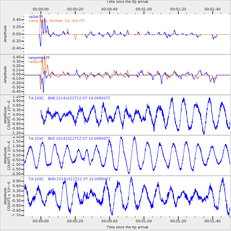
109C Camp Elliot, Mirimar, CA, USA - Earthquake Result Viewer
| Earthquake location: |
Northern Mid-Atlantic Ridge |
| Earthquake latitude/longitude: |
15.0/-44.9 |
| Earthquake time(UTC): |
2014/10/22 (295) 21:56:56 GMT |
| Earthquake Depth: |
12 km |
| Earthquake Magnitude: |
4.9 MW |
| Earthquake Catalog/Contributor: |
ISC/ISC |
|
| Network: |
TA USArray Transportable Network (new EarthScope stations) |
| Station: |
109C Camp Elliot, Mirimar, CA, USA |
| Lat/Lon: |
32.89 N/117.11 W |
| Elevation: |
150 m |
|
| Distance: |
67.2 deg |
| Az: |
299.652 deg |
| Baz: |
86.464 deg |
| Ray Param: |
0.057111885 |
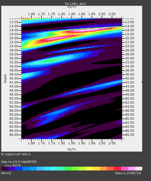
| Estimated Moho Depth: |
15.5 km |
| Estimated Crust Vp/Vs: |
1.94 |
| Assumed Crust Vp: |
6.264 km/s |
| Estimated Crust Vs: |
3.233 km/s |
| Estimated Crust Poisson's Ratio: |
0.32 |
|
| Radial Match: |
87.9013 % |
| Radial Bump: |
400 |
| Transverse Match: |
82.653275 % |
| Transverse Bump: |
400 |
| SOD ConfigId: |
3390531 |
| Insert Time: |
2019-04-14 16:36:12.798 +0000 |
| GWidth: |
2.5 |
| Max Bumps: |
400 |
| Tol: |
0.001 |
|
Signal To Noise
| Channel | StoN | STA | LTA |
| TA:109C: :BHZ:20141022T22:07:19.068997Z | 2.0296128 | 9.653576E-7 | 4.7563634E-7 |
| TA:109C: :BHN:20141022T22:07:19.068997Z | 0.90345913 | 3.096571E-7 | 3.4274612E-7 |
| TA:109C: :BHE:20141022T22:07:19.068997Z | 1.8704772 | 4.4927353E-7 | 2.4019192E-7 |
| Arrivals |
| Ps | 2.4 SECOND |
| PpPs | 7.0 SECOND |
| PsPs/PpSs | 9.4 SECOND |


