You are here: Home > Network List > II - Global Seismograph Network (GSN - IRIS/IDA) Stations List
> Station PALK Pallekele, Sri Lanka > Earthquake Result Viewer
PALK Pallekele, Sri Lanka - Earthquake Result Viewer
| Earthquake location: |
Eastern New Guinea Reg., P.N.G. |
| Earthquake latitude/longitude: |
-6.7/147.3 |
| Earthquake time(UTC): |
2010/04/17 (107) 23:15:22 GMT |
| Earthquake Depth: |
53 km |
| Earthquake Magnitude: |
6.2 MW, 6.2 MW, 6.2 MB |
| Earthquake Catalog/Contributor: |
NEIC PDE/NEIC PDE-M |
|
| Network: |
II Global Seismograph Network (GSN - IRIS/IDA) |
| Station: |
PALK Pallekele, Sri Lanka |
| Lat/Lon: |
7.27 N/80.70 E |
| Elevation: |
460 m |
|
| Distance: |
67.9 deg |
| Az: |
280.601 deg |
| Baz: |
100.204 deg |
| Ray Param: |
0.056577545 |
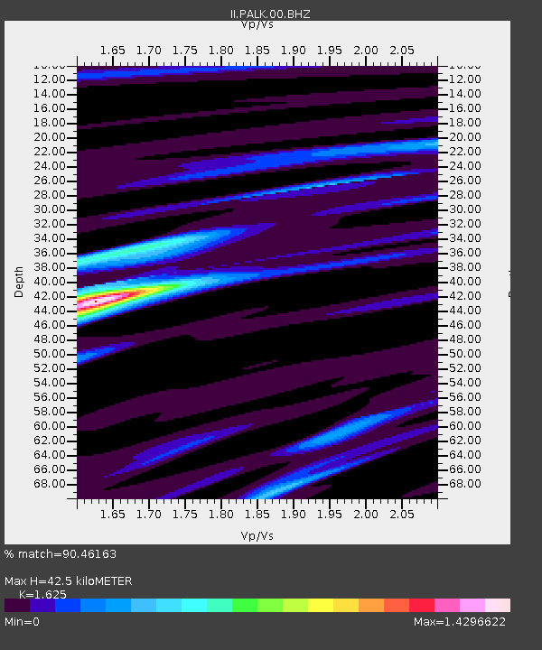
| Estimated Moho Depth: |
42.5 km |
| Estimated Crust Vp/Vs: |
1.62 |
| Assumed Crust Vp: |
6.545 km/s |
| Estimated Crust Vs: |
4.028 km/s |
| Estimated Crust Poisson's Ratio: |
0.20 |
|
| Radial Match: |
90.46163 % |
| Radial Bump: |
400 |
| Transverse Match: |
86.19883 % |
| Transverse Bump: |
400 |
| SOD ConfigId: |
617450 |
| Insert Time: |
2013-10-01 04:09:54.552 +0000 |
| GWidth: |
2.5 |
| Max Bumps: |
400 |
| Tol: |
0.001 |
|
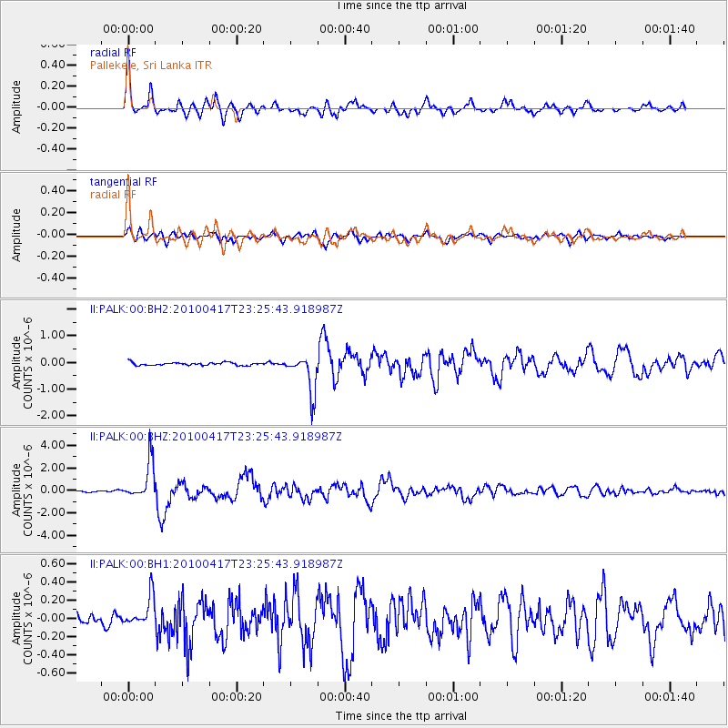
Signal To Noise
| Channel | StoN | STA | LTA |
| II:PALK:00:BHZ:20100417T23:25:43.918987Z | 18.260105 | 1.7009711E-6 | 9.3152316E-8 |
| II:PALK:00:BH1:20100417T23:25:43.918987Z | 3.30479 | 1.6964712E-7 | 5.1333707E-8 |
| II:PALK:00:BH2:20100417T23:25:43.918987Z | 14.173977 | 7.3425565E-7 | 5.180308E-8 |
| Arrivals |
| Ps | 4.2 SECOND |
| PpPs | 16 SECOND |
| PsPs/PpSs | 21 SECOND |


