You are here: Home > Network List > II - Global Seismograph Network (GSN - IRIS/IDA) Stations List
> Station AAK Ala Archa, Kyrgyzstan > Earthquake Result Viewer
AAK Ala Archa, Kyrgyzstan - Earthquake Result Viewer
| Earthquake location: |
Irian Jaya, Indonesia |
| Earthquake latitude/longitude: |
-3.7/140.3 |
| Earthquake time(UTC): |
1995/12/19 (353) 23:28:12 GMT |
| Earthquake Depth: |
71 km |
| Earthquake Magnitude: |
6.2 MB, 6.5 UNKNOWN |
| Earthquake Catalog/Contributor: |
WHDF/NEIC |
|
| Network: |
II Global Seismograph Network (GSN - IRIS/IDA) |
| Station: |
AAK Ala Archa, Kyrgyzstan |
| Lat/Lon: |
42.64 N/74.49 E |
| Elevation: |
1645 m |
|
| Distance: |
75.0 deg |
| Az: |
315.839 deg |
| Baz: |
109.574 deg |
| Ray Param: |
0.051815208 |
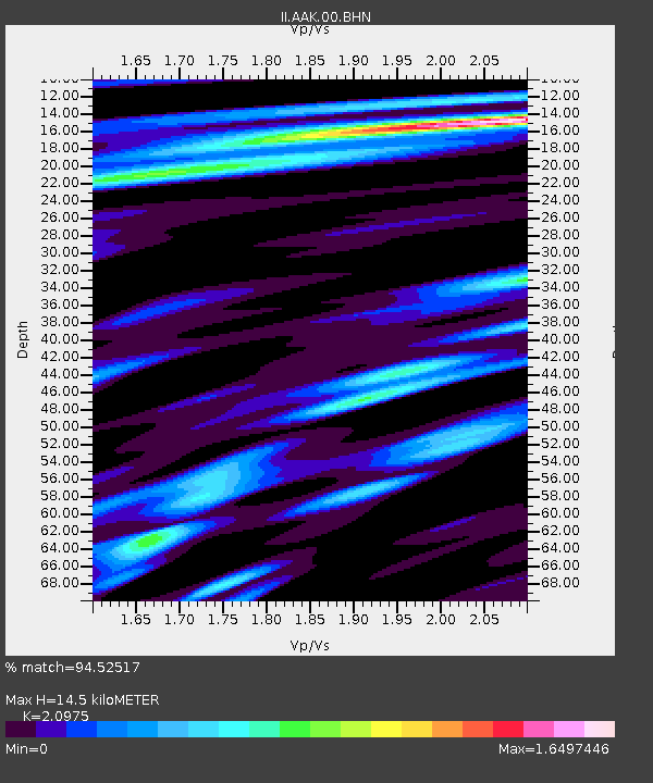
| Estimated Moho Depth: |
14.5 km |
| Estimated Crust Vp/Vs: |
2.10 |
| Assumed Crust Vp: |
6.306 km/s |
| Estimated Crust Vs: |
3.006 km/s |
| Estimated Crust Poisson's Ratio: |
0.35 |
|
| Radial Match: |
94.52517 % |
| Radial Bump: |
400 |
| Transverse Match: |
91.61344 % |
| Transverse Bump: |
400 |
| SOD ConfigId: |
61242 |
| Insert Time: |
2010-03-01 15:35:35.625 +0000 |
| GWidth: |
2.5 |
| Max Bumps: |
400 |
| Tol: |
0.001 |
|

Signal To Noise
| Channel | StoN | STA | LTA |
| II:AAK:00:BHN:19951219T23:39:15.57301Z | 0.8276462 | 5.8749947E-8 | 7.098437E-8 |
| II:AAK:00:BHE:19951219T23:39:15.57301Z | 3.3686998 | 2.1796758E-7 | 6.470377E-8 |
| II:AAK:00:BHZ:19951219T23:39:15.57301Z | 9.602228 | 7.406659E-7 | 7.713479E-8 |
| Arrivals |
| Ps | 2.6 SECOND |
| PpPs | 6.9 SECOND |
| PsPs/PpSs | 9.5 SECOND |


