You are here: Home > Network List > US - United States National Seismic Network Stations List
> Station WMOK Wichita Mountains, Oklahoma, USA > Earthquake Result Viewer
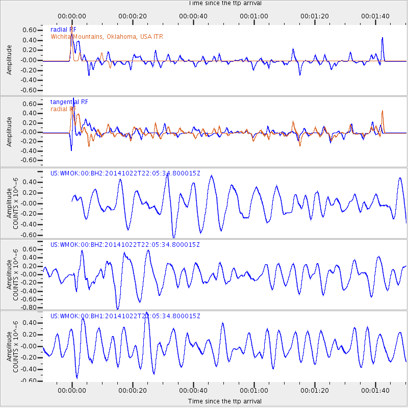
WMOK Wichita Mountains, Oklahoma, USA - Earthquake Result Viewer
*The percent match for this event was below the threshold and hence no stack was calculated.
| Earthquake location: |
Northern Mid-Atlantic Ridge |
| Earthquake latitude/longitude: |
15.0/-44.9 |
| Earthquake time(UTC): |
2014/10/22 (295) 21:56:56 GMT |
| Earthquake Depth: |
12 km |
| Earthquake Magnitude: |
4.9 MW |
| Earthquake Catalog/Contributor: |
ISC/ISC |
|
| Network: |
US United States National Seismic Network |
| Station: |
WMOK Wichita Mountains, Oklahoma, USA |
| Lat/Lon: |
34.74 N/98.78 W |
| Elevation: |
486 m |
|
| Distance: |
52.0 deg |
| Az: |
302.464 deg |
| Baz: |
98.11 deg |
| Ray Param: |
$rayparam |
*The percent match for this event was below the threshold and hence was not used in the summary stack. |
|
| Radial Match: |
67.799934 % |
| Radial Bump: |
400 |
| Transverse Match: |
46.695053 % |
| Transverse Bump: |
400 |
| SOD ConfigId: |
3390531 |
| Insert Time: |
2019-04-14 16:37:43.455 +0000 |
| GWidth: |
2.5 |
| Max Bumps: |
400 |
| Tol: |
0.001 |
|
Signal To Noise
| Channel | StoN | STA | LTA |
| US:WMOK:00:BHZ:20141022T22:05:34.800015Z | 1.2621909 | 2.5671613E-7 | 2.0338932E-7 |
| US:WMOK:00:BH1:20141022T22:05:34.800015Z | 2.0560586 | 3.352691E-7 | 1.6306397E-7 |
| US:WMOK:00:BH2:20141022T22:05:34.800015Z | 1.9442141 | 3.8449855E-7 | 1.9776554E-7 |
| Arrivals |
| Ps | |
| PpPs | |
| PsPs/PpSs | |


