You are here: Home > Network List > X812 - Deep Structure of Three Continental Sutures in Eastern North America Stations List
> Station QM20 Hay Lake, Maine, USA > Earthquake Result Viewer
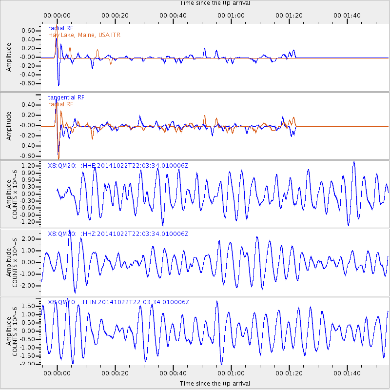
QM20 Hay Lake, Maine, USA - Earthquake Result Viewer
*The percent match for this event was below the threshold and hence no stack was calculated.
| Earthquake location: |
Northern Mid-Atlantic Ridge |
| Earthquake latitude/longitude: |
15.0/-44.9 |
| Earthquake time(UTC): |
2014/10/22 (295) 21:56:56 GMT |
| Earthquake Depth: |
12 km |
| Earthquake Magnitude: |
4.9 MW |
| Earthquake Catalog/Contributor: |
ISC/ISC |
|
| Network: |
X8 Deep Structure of Three Continental Sutures in Eastern North America |
| Station: |
QM20 Hay Lake, Maine, USA |
| Lat/Lon: |
46.13 N/68.72 W |
| Elevation: |
207 m |
|
| Distance: |
36.9 deg |
| Az: |
332.112 deg |
| Baz: |
139.465 deg |
| Ray Param: |
$rayparam |
*The percent match for this event was below the threshold and hence was not used in the summary stack. |
|
| Radial Match: |
64.83971 % |
| Radial Bump: |
400 |
| Transverse Match: |
58.45058 % |
| Transverse Bump: |
400 |
| SOD ConfigId: |
3390531 |
| Insert Time: |
2019-04-14 16:38:13.658 +0000 |
| GWidth: |
2.5 |
| Max Bumps: |
400 |
| Tol: |
0.001 |
|
Signal To Noise
| Channel | StoN | STA | LTA |
| X8:QM20: :HHZ:20141022T22:03:34.010006Z | 1.4932904 | 1.2269263E-6 | 8.2162603E-7 |
| X8:QM20: :HHN:20141022T22:03:34.010006Z | 2.1601388 | 1.3062125E-6 | 6.0468915E-7 |
| X8:QM20: :HHE:20141022T22:03:34.010006Z | 1.1109842 | 5.6631956E-7 | 5.097458E-7 |
| Arrivals |
| Ps | |
| PpPs | |
| PsPs/PpSs | |


