You are here: Home > Network List > II - Global Seismograph Network (GSN - IRIS/IDA) Stations List
> Station PALK Pallekele, Sri Lanka > Earthquake Result Viewer
PALK Pallekele, Sri Lanka - Earthquake Result Viewer
| Earthquake location: |
Bering Sea |
| Earthquake latitude/longitude: |
60.5/-177.9 |
| Earthquake time(UTC): |
2010/04/30 (120) 23:11:43 GMT |
| Earthquake Depth: |
12 km |
| Earthquake Magnitude: |
6.5 MW, 6.0 MB, 6.4 MW, 6.7 MS |
| Earthquake Catalog/Contributor: |
NEIC PDE/NEIC PDE-M |
|
| Network: |
II Global Seismograph Network (GSN - IRIS/IDA) |
| Station: |
PALK Pallekele, Sri Lanka |
| Lat/Lon: |
7.27 N/80.70 E |
| Elevation: |
460 m |
|
| Distance: |
89.3 deg |
| Az: |
283.471 deg |
| Baz: |
29.05 deg |
| Ray Param: |
0.041935883 |
| Estimated Moho Depth: |
10.0 km |
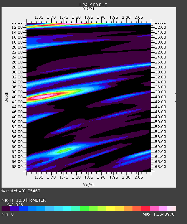
| Estimated Crust Vp/Vs: |
1.83 |
| Assumed Crust Vp: |
6.545 km/s |
| Estimated Crust Vs: |
3.586 km/s |
| Estimated Crust Poisson's Ratio: |
0.29 |
|
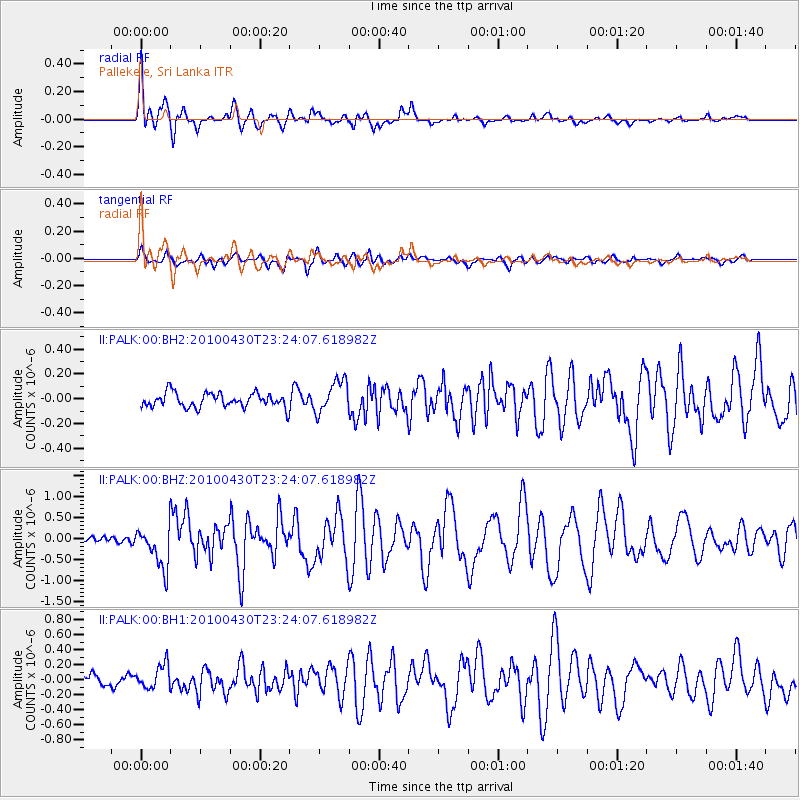
| Radial Match: |
91.25463 % |
| Radial Bump: |
400 |
| Transverse Match: |
81.04432 % |
| Transverse Bump: |
400 |
| SOD ConfigId: |
617450 |
| Insert Time: |
2013-10-01 04:32:13.158 +0000 |
| GWidth: |
2.5 |
| Max Bumps: |
400 |
| Tol: |
0.001 |
|
Signal To Noise
| Channel | StoN | STA | LTA |
| II:PALK:00:BHZ:20100430T23:24:07.618982Z | 7.333351 | 4.965016E-7 | 6.7704605E-8 |
| II:PALK:00:BH1:20100430T23:24:07.618982Z | 2.4700546 | 1.5980824E-7 | 6.469826E-8 |
| II:PALK:00:BH2:20100430T23:24:07.618982Z | 2.2896724 | 1.3086253E-7 | 5.715339E-8 |
| Arrivals |
| Ps | 1.3 SECOND |
| PpPs | 4.2 SECOND |
| PsPs/PpSs | 5.5 SECOND |


