You are here: Home > Network List > IU - Global Seismograph Network (GSN - IRIS/USGS) Stations List
> Station KEV Kevo, Finland > Earthquake Result Viewer
KEV Kevo, Finland - Earthquake Result Viewer
| Earthquake location: |
Bering Sea |
| Earthquake latitude/longitude: |
60.5/-177.9 |
| Earthquake time(UTC): |
2010/04/30 (120) 23:11:43 GMT |
| Earthquake Depth: |
12 km |
| Earthquake Magnitude: |
6.5 MW, 6.0 MB, 6.4 MW, 6.7 MS |
| Earthquake Catalog/Contributor: |
NEIC PDE/NEIC PDE-M |
|
| Network: |
IU Global Seismograph Network (GSN - IRIS/USGS) |
| Station: |
KEV Kevo, Finland |
| Lat/Lon: |
69.76 N/27.00 E |
| Elevation: |
100 m |
|
| Distance: |
48.9 deg |
| Az: |
348.787 deg |
| Baz: |
16.066 deg |
| Ray Param: |
0.06907836 |
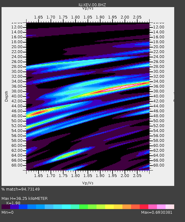
| Estimated Moho Depth: |
36.25 km |
| Estimated Crust Vp/Vs: |
1.98 |
| Assumed Crust Vp: |
6.622 km/s |
| Estimated Crust Vs: |
3.345 km/s |
| Estimated Crust Poisson's Ratio: |
0.33 |
|
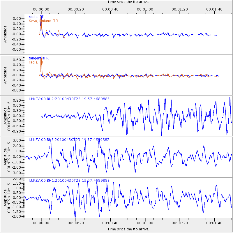
| Radial Match: |
94.73149 % |
| Radial Bump: |
290 |
| Transverse Match: |
76.2908 % |
| Transverse Bump: |
400 |
| SOD ConfigId: |
617450 |
| Insert Time: |
2013-10-01 04:32:26.479 +0000 |
| GWidth: |
2.5 |
| Max Bumps: |
400 |
| Tol: |
0.001 |
|
Signal To Noise
| Channel | StoN | STA | LTA |
| IU:KEV:00:BHZ:20100430T23:19:57.468988Z | 4.9627876 | 6.183618E-7 | 1.245997E-7 |
| IU:KEV:00:BH1:20100430T23:19:57.468988Z | 3.1727624 | 3.141119E-7 | 9.9002655E-8 |
| IU:KEV:00:BH2:20100430T23:19:57.468988Z | 2.6239626 | 1.7645056E-7 | 6.7245836E-8 |
| Arrivals |
| Ps | 5.7 SECOND |
| PpPs | 15 SECOND |
| PsPs/PpSs | 21 SECOND |


